| Hawaii Road
Sign Photos by Oscar Voss (page 1 of 3)
This three-page photo collection is a subset of the Road
Photos collection for my Hawaii Highways site,
focusing on road signs I found throughout the islands on my trips there
in autumn 1999, May 2000, November 2001, and spring 2005, as well as a few photographed
by others (all photos are mine unless otherwise noted). These include more than three
dozen photos, covering not only examples of standard signage, but also
some variants thereof, and also some of the more interesting road signs
in the state.
Page 1, below, focuses on route markers and milemarkers for state and county highways. Page 2 is devoted to route markers and other signage on Hawaii's four Interstates. Page 3 covers other kinds of road signs, both those common throughout the
islands, and some of the more unique signs I've seen here and there.
NOTE: In case you want more detail, clicking a few of the
photos below will call up enlarged, higher-quality (less .jpg compression)
versions. Those alternate versions have larger file sizes, so please be
patient while they download.
|
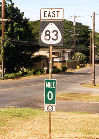
 A standard
Hawaii state highway route marker, with a standard mile marker (with route
number), at the south end of old state route 83 (part of the Kamehameha
Highway) in Haleiwa on Oahu's north shore, where it joins state routes
99 and 930. This stretch has been bypassed by another two-lane road,
which now carries the route 83 designation, but this sign assembly on the old route was still
there in May 2005. (September 1999) A standard
Hawaii state highway route marker, with a standard mile marker (with route
number), at the south end of old state route 83 (part of the Kamehameha
Highway) in Haleiwa on Oahu's north shore, where it joins state routes
99 and 930. This stretch has been bypassed by another two-lane road,
which now carries the route 83 designation, but this sign assembly on the old route was still
there in May 2005. (September 1999)
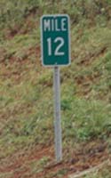
County routes in Hawaii are usually marked the same way as state
highways (see below for exceptions), but the minor county routes are often
marked only with milepost assemblies like those on the right, without shields.
|
 |
|
 A nonstandard milemarker on Oahu's Interstate H-3, with the number horizontal rather than vertical (the usual style, as shown
in the route 56 marker below). This style is also used on some county highways. (November 2001) A nonstandard milemarker on Oahu's Interstate H-3, with the number horizontal rather than vertical (the usual style, as shown
in the route 56 marker below). This style is also used on some county highways. (November 2001)
|
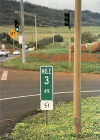
 Hawaii routes usually do not have "BEGIN" and "END" signs at each end.
Instead, where the start and finish of the road is not obvious, there is
normally a zero milepost at one end (see route 83 marker above), and a terminal milepost
indicating the ending mileage to two decimal places (see right, mile
3.49 at the north end of route 51 on Kauai). (November 2001)
 |
|
 |
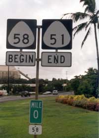 |
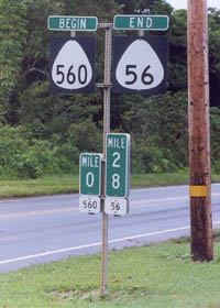
 "END" signs are rare throughout the islands, and "BEGIN" signs are still more rare. These two examples are on Kauai, where a road changes route
number for no obvious reason (above left, where the Kuhio Highway changes
from a two-digit primary to a three-digit secondary route in Princeville;
above left, where Waapa Road on route 51 becomes Nawiliwili Road on route
58). (Both photos November 2001) "END" signs are rare throughout the islands, and "BEGIN" signs are still more rare. These two examples are on Kauai, where a road changes route
number for no obvious reason (above left, where the Kuhio Highway changes
from a two-digit primary to a three-digit secondary route in Princeville;
above left, where Waapa Road on route 51 becomes Nawiliwili Road on route
58). (Both photos November 2001)
|
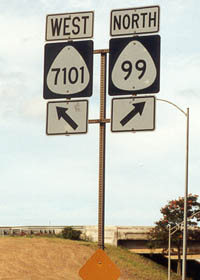
 An example
of a shield for Hawaii's usually unsigned 4-digit state routes, this one
at the southern junction of Oahu's Farrington and Kamehameha Highways.
Most of them are on Oahu, often near the island's many military installations
(Maui and the Big Island also have 4dis). Many Hawaii 4dis are minor
roads that otherwise would not be in the state highway system. (May 2000) An example
of a shield for Hawaii's usually unsigned 4-digit state routes, this one
at the southern junction of Oahu's Farrington and Kamehameha Highways.
Most of them are on Oahu, often near the island's many military installations
(Maui and the Big Island also have 4dis). Many Hawaii 4dis are minor
roads that otherwise would not be in the state highway system. (May 2000) |
|
|
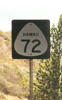
 A rare style of state route shield with the state name, found at three places on the Kalanianaole Highway (state route 72) south of Kailua in southeastern Oahu. As far as I know, there are no similar route shields anywhere else in the state. (September 1999) A rare style of state route shield with the state name, found at three places on the Kalanianaole Highway (state route 72) south of Kailua in southeastern Oahu. As far as I know, there are no similar route shields anywhere else in the state. (September 1999) |
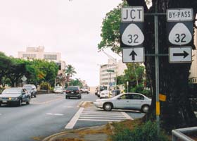
 In downtown Wailuku on Maui, at the intersection of Wells Street with High Street (east end of state route 30), this signed "by-pass" route marker encourages eastbound travelers to get off High Street before the congested intersection with Main Street (state route 32). While this is not the only current designated bypass route in Hawaii, as far as I know this is the state's only bypass or other bannered route marker, other than some incomplete sign assemblies elsewhere in downtown Wailuku for several former "by-pass" routes. (May 2005) In downtown Wailuku on Maui, at the intersection of Wells Street with High Street (east end of state route 30), this signed "by-pass" route marker encourages eastbound travelers to get off High Street before the congested intersection with Main Street (state route 32). While this is not the only current designated bypass route in Hawaii, as far as I know this is the state's only bypass or other bannered route marker, other than some incomplete sign assemblies elsewhere in downtown Wailuku for several former "by-pass" routes. (May 2005)
|
|
 |
 |
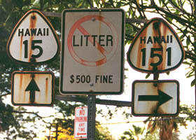
 These cutout-style
shields are sometimes found (but increasingly rare) on former routes long removed from the state highway
system, as with old route 15 and 151 in Pahala on the Big Island. (May 2000) These cutout-style
shields are sometimes found (but increasingly rare) on former routes long removed from the state highway
system, as with old route 15 and 151 in Pahala on the Big Island. (May 2000) |
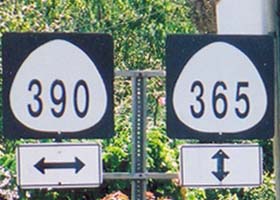
 Route shields on county routes, where they exist at all (many county routes are unsigned, or marked only with milemarkers), are usually identical to state highway
shields. On Maui, however, many of the newer county route shields slightly differ from the standard state design, with a rounder white background and a different number font, as shown here at the intersection of county routes 365 and 390 in downtown Makawao. (May 2005) Route shields on county routes, where they exist at all (many county routes are unsigned, or marked only with milemarkers), are usually identical to state highway
shields. On Maui, however, many of the newer county route shields slightly differ from the standard state design, with a rounder white background and a different number font, as shown here at the intersection of county routes 365 and 390 in downtown Makawao. (May 2005)
|
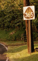 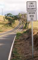 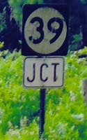 |
 For some reason, all the oddball county route markers I've seen in Hawaii are on Maui. Maui County apparently once used as its standard "photo negative" shields like the one above left on Maui route 365 north of Makawao (no longer there, but there are still a few others in central Maui). Maui County also marks its segment of the Piilani Highway (route 31 south of the Haleakala volcano, shown where it joins state highway 37 south of Kula) in a less interesting way, shown in the center photo above. Finally, above right is a photo of route 39 marker with the number within a white round background, at the junction of county route 394 with county route 390 (apparently dating back to the early post-statehood era, when many 3-digit secondary routes were signed with only the first two digits). That sign, and a heavily-damaged one west of that junction on route 390, are the only ones of that kind I've seen in Hawaii. (May 2000, November 2001, and May 2005 respectively) For some reason, all the oddball county route markers I've seen in Hawaii are on Maui. Maui County apparently once used as its standard "photo negative" shields like the one above left on Maui route 365 north of Makawao (no longer there, but there are still a few others in central Maui). Maui County also marks its segment of the Piilani Highway (route 31 south of the Haleakala volcano, shown where it joins state highway 37 south of Kula) in a less interesting way, shown in the center photo above. Finally, above right is a photo of route 39 marker with the number within a white round background, at the junction of county route 394 with county route 390 (apparently dating back to the early post-statehood era, when many 3-digit secondary routes were signed with only the first two digits). That sign, and a heavily-damaged one west of that junction on route 390, are the only ones of that kind I've seen in Hawaii. (May 2000, November 2001, and May 2005 respectively)
|
|
 Some routes
change from state to county jurisdiction, while keeping the same number,
with no notice other than an "end state highway" sign like this one on
Maui's Kahekili Highway (state, then county, route 340) north of Wailuku.
Note the route 340 shield in the background, past the "end state highway"
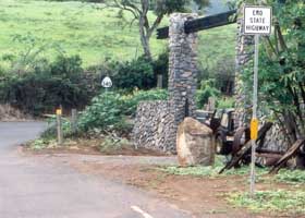
sign. (November 2001) Some routes
change from state to county jurisdiction, while keeping the same number,
with no notice other than an "end state highway" sign like this one on
Maui's Kahekili Highway (state, then county, route 340) north of Wailuku.
Note the route 340 shield in the background, past the "end state highway"
sign. (November 2001)
|
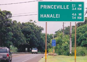
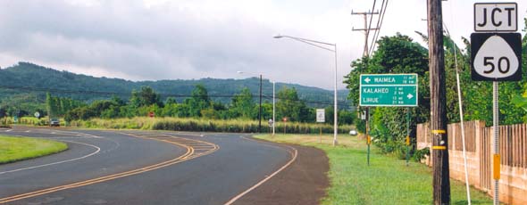
  Hawaii generally doesn't have much metric signage on its roads, except on Kauai, where the newer signs on state highways often show metric distances, such as on the sign to the right in northern Kauai on state route 56 approaching Princeville from the east, and at the sign below in southern Kauai at the eastern end of state route 540 where it joins state route 50. (Both photos June 2005) Hawaii generally doesn't have much metric signage on its roads, except on Kauai, where the newer signs on state highways often show metric distances, such as on the sign to the right in northern Kauai on state route 56 approaching Princeville from the east, and at the sign below in southern Kauai at the eastern end of state route 540 where it joins state route 50. (Both photos June 2005) |
 |
|
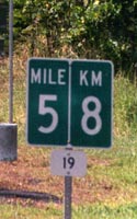
 A combination milemarker with the approximate metric equivalent appears on a few state highways outside Kauai, such as this one along the Hawaii Belt Road (state route 19) north of Hilo. Aside from signs like this combination marker and the Kauai signs shown above, metric signage is rare or nonexistent on Hawaii's roads. (October 1999) A combination milemarker with the approximate metric equivalent appears on a few state highways outside Kauai, such as this one along the Hawaii Belt Road (state route 19) north of Hilo. Aside from signs like this combination marker and the Kauai signs shown above, metric signage is rare or nonexistent on Hawaii's roads. (October 1999)
|
 |

Page 2: other Hawaii road signs
or go on to Page 3: miscellaneous other road signs
|
© Oscar Voss 1999-2001, 2003-2007. Last revised March 2007.
Comments, etc.? Please e-mail me. |


