This page is a guide to what is where on the Hawaii Highways site, and how to navigate around the site. For a summary of how this version 2.5 of the Hawaii Highways site has changed from C.C. Slater's original Hawaii State Highways site and from the 2nd edition, as well as recent updates, see the "What's New" page.
For a quick overview of how the site's organized, please consult the site map.
Spelling and language
This site was originally written in Commonwealth English, a style preference of the original author that I chose to honor at first. Since "Pearl Harbour" freaks out some people, I have changed to American spellings as the site was updated, though some stray Commonwealth spellings may remain here and there.
Hawaiian place names shown here do not include all the diacritical marks that might appear in a proper Hawaiian-language rendering -- for example, "Hawaii" rather than "Hawai'i" is used here. Sometimes the diacriticals are very important -- in Hawaiian, just one diacritical mark makes all the difference between "eating" and "having sex" -- but usually not for road and place names. Omitting the diacriticals is consistent with conventional usage, and in particular what often appears on road signs. Also, many browsers don't properly display the Hawaiian language's two diacritical marks, the okina (' glottal stop, like in "o'o" which is pronounced "oh-oh") and the kahako (macron, a straight line over a vowel to elongate its sound, like for the first "o" in "Maui no ka 'oi"). I sometimes use ' for the okina, where useful and particularly where commonly used on road signs, such as to distinguish the Hawaiian word "ha'iku" from the differently-pronounced word for a type of Japanese poetry.
Hawaiian pronunciations often differ from those of similar-looking English words. For example, "Likelike" (as in the Likelike Highway on Oahu, named for the late Princess Miriam Likelike) is pronounced "lee-keh-lee-keh" rather than "like-like." Unless you don't mind being instantly recognized as a tourist, buy a basic little phrasebook upon or before your arrival in the islands, or before you go, run through some of the tutorials available at the very helpful Hawaiian Language web site.
This site has four major types of substantive information, Route Lists, Exit Guides, Road Photos, and Frequently Asked Questions (FAQs), in addition to a consolidated Credits and Sources page covering the entire site.
Route ListsThere are route lists for each of the major Hawaiian islands (excluding privately-owned Niihau, which has no public roads, and Kahoolawe, uninhabited and essentially off-limits to the general public). The route lists are spread over nine pages: a combined page for the short Lanai and Molokai route lists (route numbers beginning with 4), a single page for Kauai (route numbers beginning with 5), two pages each for Oahu (Interstates, and other route numbers beginning with 6, 7, 8, or 9) and Maui (non-Interstate route numbers beginning with 3), and three pages for the Big Island (Hawaii island) (non-Interstate route numbers beginning with 1 or 2).
The following is an excerpt from one of the route lists, illustrating the kind of information provided (actual type size is larger):
| Oahu (table 2) | |||
| Route | Name | Termini/other road info | Mileage |
| Former
County  (part) |
Wilikina Drive (part) |
JN |
1.8 miles |
Former (part) |
Farrington Highway (part of southern segment) |
JN |
5.0 miles |
County
 |
Middle Street (part) |
JN |
0.4 miles |
 |
Middle Street (part) |
JN Keehi Interchange |
0.5 miles |
 |
Round Top Drive |
JN |
~4.9 miles |
| Photo | The Round Top/Tantalus scenic drive is very slow and winding. Allow two hours. | ||
|
Admiral Clarey Bridge |
Combined fixed-span and retractable concrete pontoon floating bridge within Pearl Harbor Naval base, from Ford Island to harbor shore near JN |
0.9 miles |
| CLOSED TO GENERAL PUBLIC (except via shuttle bus for tour of U.S.S. Missouri, which is docked at Ford Island). | |||
| Photos | See the FAQs for more information about this bridge. | ||
Each listing contains the route number and name of the road or segment thereof, where it begins and ends, and its length (based on official route logs where possible, otherwise estimated). Where a numbered highway route includes parts of two or more roads, each segment is listed separately. Where only part of a road is included in a numbered route segment, that is so indicated in the "Name" column, with the next column usually indicating in some fashion whether the rest of the road is part of another numbered route (sometimes with a cross-reference to the corresponding listing). Also, where a numbered route segment includes only part of the numbered route, that is so indicated in the "Number" column.
Many listings include additional information, such as limited information on the road's history (including any other route numbers that may once have been assigned to the road, some of which still appear on maps); whether the road lacks route signs, or other indication of the route number; plans for major improvements; sometimes a link to the relevant road photos collection, or other material, elsewhere on this site (see "Road Photos" below); and warnings about road conditions and closures. (Short-term closures are not included on the route lists -- check with Hawaii DOT, or for non-state roads inquire locally, for the very latest such information.)
NOTE: Warnings and cautions on road conditions are provided mainly for numbered state routes, and the most difficult county and other routes (including the unpaved ones). The routes outside the numbered state highway system for which there are no alerts may nevertheless have narrow, rough, and/or winding pavement, one-lane bridges, or other limitations. Also, no information is provided on weight or other load restrictions on highway bridges (I've seen weight limits as low as two or three tons on some county bridges), or on horizontal and vertical clearances; truckers and others that might be affected will have to look elsewhere for that information.
Included in the route lists are both state and county highways (many of the county highways used to be part of the state highway system, and their route shields usually are identical to those on state highways), as well as a few roads maintained by other jurisdictions such as the National Park Service. The lists include also some significant unnumbered highways, and roads that used to be numbered state or county highways (some of those roads no longer exist, or are now closed to the general public). This site does not have (except for a brief discussion in the FAQs) any information about signed route numbers under the temporary wartime Federal route system on Oahu during the 1940s, or the generally unsigned Federal-aid route numbers used before the "great renumbering" of the mid-1950s, which established the basic route numbering system used after Hawaii became a state.
Each route list is preceded by this heading like this, indicating how the list differentiates among the different kinds of routes (actual type size is larger):
.![]() State route
State route ![]() County route
County route ![]()
![]() Former route
Former route ![]() Other unnumbered route
Other unnumbered route
(Actual county route shields are usually identical to state shields; see the FAQs for how routes are classified in the listings below.
Also, in many browsers letting your mouse linger over a route number graphic will help you decipher it.)
As the heading reminds, in many browsers (including Internet Explorer) the ALT tags for route number graphics will help you figure out what they stand for, so if you forget you don't have to go back to the top of the page to look up the key.
Former routes (not currently in the numbered state or county highway systems) are also highlighted by listings with gray backgrounds, as with the old route 90 (Farrington Highway) listing above. Roads in national parks are similarly distinguished by the brown backgrounds of their listings. The few completely new highways in the works (such as planned state route 374 on Maui) are indicated as "future" routes, with light green backgrounds for their listings.
The identification of routes as existing state routes is reasonably definitive (subject to late-breaking changes to the state route system), but the categorization of other routes as "county route," "former state route," and "former county route" involves some judgment calls, which I explain in detail in the FAQs.
In addition, all route lists have two cross-indices. The name cross-index lists roads in alphabetical order, with their corresponding listings in the generally number-ordered main route list. The former routes cross-index similarly ties old route numbers (post-statehood) to the corresponding renumbered roads in the main route list.
Finally, each route list, and each of the Oahu Freeways exit guides, is preceded by a link to a zoomable Google online map of the relevant island, to help you locate the listed routes and their termini. (There may be some differences between the Google maps and the more up-to-date and authoritative route lists.)
Exit guidesThere is also a set of four exit guides, one for each of Hawaii's freeways (all of which are on Oahu). An excerpt from one of the guides follows (actual type size is larger):
| NORTHBOUND -- Read DOWN | Interchange Name | SOUTHBOUND -- Read UP from bottom | |||
| EXIT Number
Highway, Street or Exit Destination |
EXIT Number
Highway, Street or Exit Destination |
||||
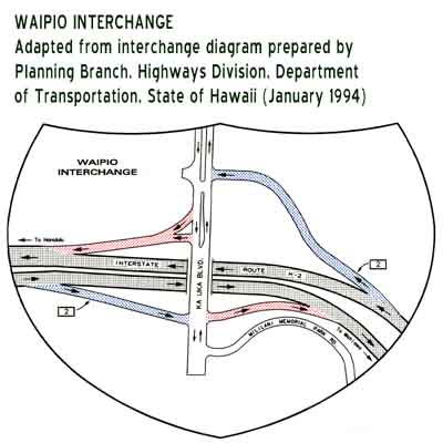
| EXIT 2 | Waipio interchange |
EXIT 2 | |||
| Ka Uka Boulevard Waipio |
Ka Uka Boulevard Waipio |
||||
| EXIT 5A | Mililani interchange |
EXIT 5 | |||
| Meheula Parkway EAST Mililani Mauka |
(Meheula Parkway) Mililani |
||||
| EXIT 5B | |||||
| Meheula Parkway WEST Mililani Town |
|||||
As you can see, the exit lists provide information separately for each direction of travel, as well as interchange names. Most interchange names have two links, with the first link to an interchange diagram graphic (where available), and the second (under the word "interchange") to a zoomable Google Map of the interchange. The exit lists attempt to provide the same basic information for each exit as you'll see on the freeway as you approach the exit. Additional information not shown on the actual exit signs, indicated by (parentheses), is also included. Some cautions are also added, particularly tunnel notices for Interstate H-3 and eastbound Interstate H-1, and the low speed limits for the S-curve on H-1 between exits 18 and 19.
Road PhotosOne of the major improvements to the site from the original version is the addition of over 330 of my road photos from all six major Hawaiian islands, taken on my vacations there in autumn 1999, May 2000, and November 2001, plus some additional photos contributed by others. (I'm still working on adding more photos from my spring 2005 trip, as well as reorganization of the road photos part of this site.) They are divided into 27 photo collections (each covering part or all of one island, except a combined page for the smallest islands Lanai and Molokai), plus the initial overview page which describes how the other pages are organized. Many of those pages include links to other relevant sites (including additional photos). In addition to the 27 main photo collections, there are four secondary collections of road photos drawn from the main pages -- a two-page statewide collection focusing on Hawaii road signs, a page of photos showing the ends of Hawaii's four Interstates on Oahu, a statewide cross-index page pulling together photos of state and county route ends, and a statewide cross-index page for photos of old-style cutout route markers.
Most of the photos are 280x200 pixels, or 200x280 pixels, so that two columns of photos will comfortably display side-by-side on most browsers, and also to reduce download times (though some photos are 590 pixels wide, spanning two columns, where the added width works better). Many of the newer photos, and some selected old photos, link to larger versions, for those who want to view particular photos in more detail and don't mind the longer downloads required; I will gradually add larger versions of more of the older photos as time permits.
Frequently Asked Questions (FAQs)Additional information about this site (such as why some guy from Virginia has a site on highways in Hawaii), and general information about the state's highway system, can be found in the Frequently Asked Questions (FAQs) part of this site. The FAQs cover lots of topics such as Hawaii's route number system, and why Hawaii has "Interstate" highways, and will be revised as needed in response to additional questions coming in from readers. They also include some light highway-related humor, such as the infamous politically-incorrect "The Genie and the Road" joke, and the inevitable bad "50 ways to leave your lava" pun.
The FAQs are split into six pages, the first of which has a table of contents so you can go straight to whatever topic you're interested in, or you can just peruse all of the FAQs using the big "Go Back" and "Continue" buttons as applicable at the bottom.
The FAQs have some information on the history of Hawaii's highway system, but I may eventually incorporate that and additional information into a separate History section of this site (or perhaps adding a separate History page to the FAQs).
All of the different parts of this site are linked together in several different ways, so you usually can get from one part of this site directly to another without having to go back to the main page.
All pages except the main page, individual road photos pages (which have their own complex internal navigational structure, described below), and route list cross-index pages (which link back only to their associated route lists) have at the bottom a set of links like this:
Links to main page and other parts of Hawaii Highways site, and related sites:
The text "main page" link, as well as the alternate text links on the main page, let you make your way around this site even with graphics turned off -- however, many of the pages on this site will be unintelligible unless your browser can display graphics (or at the very least the ALT tags used for most non-photo images).
The remaining "button bar" links let you bypass the Hawaii Highways main page if you want, or go back there if you want another look at my Don Ho rant (look for the button with the smiley face, either the first or the last button depending on where you are within this site). The eleven such links (two rows of six, with one blank on the second row) are different for each page -- for example, on the FAQs page, the "FAQs" button above is replaced with one to take you back to this site guide. The "Hawaii DOT" button is an external link to Hawaii DOT Highways Division's useful website. All the buttons have tags that, with the most common browsers, will show a less cryptic description of where the link will take you, if you let the mouse pointer hover over the button. One blank blue space is normally left on the bottom row, reserved for a link to a possible new History site section, or if and when I give up on that plan, a link to the existing site map.
Some of the button links are context-specific. For example, the "Road Photos" link from the main page will take you to the overview page of the road photos collection, but the same link on the Lanai/Molokai route list page will take you to the Lanai/Molokai road photo collection, and on the Interstate H-3 exit guide, will take you straight to the Interstate H-3 photo collection. In some cases, an island-specific link will take you to one of several pages for that island (for example, the Big Island has three route list pages, and six photo pages, with only one direct link in each direction), but if you don't land on the page you want, there will be links near both the top and the bottom of the page you were sent to, that will take you to the other pages for that island.
The road photo collections have their own navigational structure. Only the overview page has a "button bar" like that shown above. Each page has big button links to the Hawaii Highways main page, and to any associated island-specific route list. The first three Oahu road photo collections, focusing on that island's freeways, also have similar links to the Oahu Freeways exit guides. All road photo collections have big "Go Back" and "Continue" button links (if applicable), with text links, near the bottom to take you through the all collections in order, as well as text links to all the other collections in case you want to skip around. Some parts of the road photos collection (Introduction, Interstate H-1, Hana Highway, Piilani Highway, Lava Closures) are split into two or more pages, each with big yellow button links to take you from one page to the other, in addition to the links described above to take you to other collections.
The FAQs also have their own supplemental navigation links, described above (a detailed table of contents on page 1, and big "Go Back" and "Continue" buttons as applicable on the bottom of each page).
Links to main page and other parts of Hawaii Highways site, and related sites:
Comments, more questions, etc.? Please e-mail me.
© Oscar Voss. Last updated July 2008.