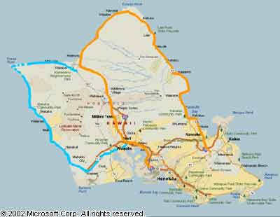
| Oahu
(table 1) |
| Route |
Name |
Termini/other
road info |
Mileage |

(part) |
Queen
Liliuokalani
Freeway |
JN  Farrington Highway north of Barbers Point, east past Pearl Harbor and Honolulu
International Airport, to Kahauiki Interchange JN Farrington Highway north of Barbers Point, east past Pearl Harbor and Honolulu
International Airport, to Kahauiki Interchange JN  Lunalilo Freeway and Lunalilo Freeway and   Moanalua Freeway (H-1 exit 19, between airport and downtown Honolulu); eastbound lanes only pass through Middle Street Tunnel (393 feet long) just before JN Lunalilo Freeway; freeway west of Kunia Interchange JN Moanalua Freeway (H-1 exit 19, between airport and downtown Honolulu); eastbound lanes only pass through Middle Street Tunnel (393 feet long) just before JN Lunalilo Freeway; freeway west of Kunia Interchange JN   (H-1 exit 5) opened in 1967, was extended to the Halawa Interchange JN (H-1 exit 5) opened in 1967, was extended to the Halawa Interchange JN  (H-1 exit 13) in 1971, then gradually extended to Kahauiki Interchange JN Lunalilo Freeway (H-1 exit 19) to complete in May 1986; parts of freeway include HOV-3 express "zipper lane" (eastbound, morning rush only) created by movable barrier out of two westbound lanes; Governor Benjamin Cayetano in October 2002 ordered freeway named for Hawaii's last
reigning monarch, Queen Lydia Liliuokalani (H-1 exit 13) in 1971, then gradually extended to Kahauiki Interchange JN Lunalilo Freeway (H-1 exit 19) to complete in May 1986; parts of freeway include HOV-3 express "zipper lane" (eastbound, morning rush only) created by movable barrier out of two westbound lanes; Governor Benjamin Cayetano in October 2002 ordered freeway named for Hawaii's last
reigning monarch, Queen Lydia Liliuokalani |
18.9
miles |
| Photos
Exit Guide |
(part) |
Lunalilo
Freeway |
Kahauiki
Interchange JN
Queen Liliuokalani Freeway and Moanalua Freeway (H-1 exit 19, between airport and downtown Honolulu), east to end of freeway at  Kalanianaole Highway and Ainakoa Avenue northeast of Diamond Head; parts of freeway (including some predating statehood, with the first segment opened in 1953) used to be part of route 72; first freeway segment built as Interstate rather than state highway, between exits 25B and 26A, opened in late 1964 or early 1965; freeway completed in July 1969; freeway long named for King William Lunalilo, who briefly reigned in the 1870s after the end of the Kamehameha dynasty Kalanianaole Highway and Ainakoa Avenue northeast of Diamond Head; parts of freeway (including some predating statehood, with the first segment opened in 1953) used to be part of route 72; first freeway segment built as Interstate rather than state highway, between exits 25B and 26A, opened in late 1964 or early 1965; freeway completed in July 1969; freeway long named for King William Lunalilo, who briefly reigned in the 1870s after the end of the Kamehameha dynasty |
8.3
miles |
| Photos
Exit Guide |
 |
Veterans
Memorial
Freeway |
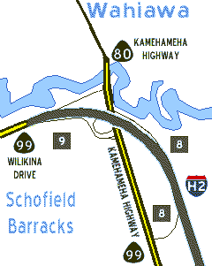
Waiawa Interchange JN Queen Liliuokalani Freeway in Waipahu (H-1 exit 8), north to Wahiawa Interchange JN   Kamehameha Highway and Wilikina Drive in Wahiawa; completed in January 1977; freeway named by Governor Cayetano in October 2002 Kamehameha Highway and Wilikina Drive in Wahiawa; completed in January 1977; freeway named by Governor Cayetano in October 2002 |
8.3
miles |
| Photos
Exit Guide |
See the Wahiawa
Interchange diagram of the confusing junction at the north end of  . . |
 |
John A.
Burns
Freeway |
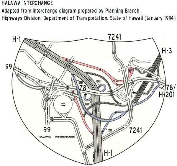
Halawa Interchange JN
Moanalua Freeway and Queen Liliuokalani Freeway near Pearl Harbor (H-1 exit 13), northeast through the Halawa Valley and the Tetsuo Harano Tunnels through the Koolau Range (westbound tunnel 5165 feet long; eastbound tunnel 4890 feet long), followed by Hospital Rock Tunnels (353 feet westbound, 354 feet eastbound), to end of freeway at culvert in front of main gate of Kaneohe Marine Corps Base Hawaii; route technically begins at ,
rather than at beginning of long ramps to and from about a mile west; route west of JN  Kamehameha Highway (H-3 exit 11) opened in December 1997; remainder of route completed in 1987, with part east of Kamehameha Highway (H-3 exit 11) opened in December 1997; remainder of route completed in 1987, with part east of  Mokapu Saddle Road opened in 1977 (via temporary connection to ); original H-3 routing was from the Halawa Interchange via planned tunnels through Red Hill into the Moanalua Valley, from which highway would have been tunneled through the Koolau Range, but that routing was abandoned due to environmental challenges, after work began in 1977 on never-completed Red Hill tunnels; Governor Cayetano renamed the Tetsuo Harano Tunnels in 2002, then later that year named the entire freeway, for the late state Gov. John A. Burns; the next year, incoming Governor Linda Lingle changed the tunnels back to their original name; Tetsuo Harano Tunnels named for former Hawaii DOT Highways Division chief; one of the nation's most expensive, controversial, and beautiful Interstates Mokapu Saddle Road opened in 1977 (via temporary connection to ); original H-3 routing was from the Halawa Interchange via planned tunnels through Red Hill into the Moanalua Valley, from which highway would have been tunneled through the Koolau Range, but that routing was abandoned due to environmental challenges, after work began in 1977 on never-completed Red Hill tunnels; Governor Cayetano renamed the Tetsuo Harano Tunnels in 2002, then later that year named the entire freeway, for the late state Gov. John A. Burns; the next year, incoming Governor Linda Lingle changed the tunnels back to their original name; Tetsuo Harano Tunnels named for former Hawaii DOT Highways Division chief; one of the nation's most expensive, controversial, and beautiful Interstates |
15.3
miles |
| Photos
Exit Guide |
There is a paved
access road winding beneath the  viaduct through the Halawa Valley, several miles long beginning at the
Hawaii DOT maintenance yard on Halawa Valley Road. The access road is CLOSED
to the general public. There also is a narrower paved road under the viaduct between the Tetsuo Harano and Hospital Rock tunnels, which is also CLOSED to most motor vehicles.
viaduct through the Halawa Valley, several miles long beginning at the
Hawaii DOT maintenance yard on Halawa Valley Road. The access road is CLOSED
to the general public. There also is a narrower paved road under the viaduct between the Tetsuo Harano and Hospital Rock tunnels, which is also CLOSED to most motor vehicles.
See the Halawa
Interchange diagram of that large, complex junction of H-3 with H-1, H-201/78, and several other roads. |
 |
Moanalua
Freeway
(part) |
JN   Moanalua Road (continuing west to Aiea), and
Kamehameha Highway near Pearl Harbor, east to Halawa Interchange JN Moanalua Freeway and Queen Liliuokalani Freeway (H-1 exit 13); east of JN Moanalua Road, used to be part of Moanalua Road, and part of route 72; interchange at western end with
Kamehameha Highway, constructed ca. 1968, may also once have been part of route 72; this and following freeway segment named for two encampments ("moana lua") where pre-automotive era travelers rested on their way between Honolulu and western Oahu Moanalua Road (continuing west to Aiea), and
Kamehameha Highway near Pearl Harbor, east to Halawa Interchange JN Moanalua Freeway and Queen Liliuokalani Freeway (H-1 exit 13); east of JN Moanalua Road, used to be part of Moanalua Road, and part of route 72; interchange at western end with
Kamehameha Highway, constructed ca. 1968, may also once have been part of route 72; this and following freeway segment named for two encampments ("moana lua") where pre-automotive era travelers rested on their way between Honolulu and western Oahu |
0.7
miles |
| Photo
Exit Guide |

Former
 |
Moanalua
Freeway
(part) |
Halawa Interchange JN Moanalua Freeway and Queen Liliuokalani Freeway near Pearl Harbor (H-1 exit 13), east to Kahauiki Interchange JN Queen Liliuokalani Freeway and Lunalilo Freeway (H-1 exit 19); officially designated as in 1990, but until July 2004 was signed only as with no visible indication of Interstate route number; some signage may still remain; a map on Hawaii DOT's web site, and some road atlases following the DOT map, incorrectly identify this freeway as state route H201; used to be part of Moanalua Road, and part of route 72; upgraded to freeway by 1984, though perhaps not up to Interstate standards until early 1990s (apparently coinciding with designation as ) |
4.1
miles |
| Photos
Exit Guide |
See the FAQs for the history of and reasons for the until-recently "secret" Interstate designation of this segment of the Moanalua Freeway. |
Former
proposed
 |
(unknown)
| Short-lived proposal, prepared by
Hawaii DOT in October 1968, to build elevated Interstate freeway along the waterfront south of downtown Honolulu,
from Keehi Interchange JN Queen
Liliuokalani Freeway (H-1 exit 18) to Kapiolani Interchange JN Lunalilo Freeway (H-1 exits 25A-B); route would have roughly followed  Dillingham Boulevard, and Dillingham Boulevard, and  Nimitz Highway and Ala Moana Boulevard, east to Ala Moana Shopping Center, then curved northeast along the Ala Wai Canal to rejoin ; Hawaii DOT considered and rejected putting part of route in submerged tunnel offshore; appears to have been prepared in response to Federal legislation authorizing additional mileage for Interstate system, which gave Hawaii DOT a chance to snag some of the new Interstate miles and the additional Federal funds that would come with them; proposal appears to have died quickly, with no mention in Hawaii DOT annual reports after fiscal year 1969; unclear whether it was killed off by public opposition, or rather (more likely) lost out to various mainland projects in the competition for the new authorized Interstate system mileage Nimitz Highway and Ala Moana Boulevard, east to Ala Moana Shopping Center, then curved northeast along the Ala Wai Canal to rejoin ; Hawaii DOT considered and rejected putting part of route in submerged tunnel offshore; appears to have been prepared in response to Federal legislation authorizing additional mileage for Interstate system, which gave Hawaii DOT a chance to snag some of the new Interstate miles and the additional Federal funds that would come with them; proposal appears to have died quickly, with no mention in Hawaii DOT annual reports after fiscal year 1969; unclear whether it was killed off by public opposition, or rather (more likely) lost out to various mainland projects in the competition for the new authorized Interstate system mileage |
6.5
miles |
Former
private
auto
ferry

(old
logo) |
The private Hawaii Superferry auto ferry system was not part of the Interstate, state, or any other public highway system, even though its initial logo looked somewhat like an Interstate H-4 sign. The system began carrying autos, trucks, and passengers between Honolulu and Maui in August 2007 (service briefly also included Kauai). Service was indefinitely suspended in March 2009, and the company went into bankruptcy soon thereafter. Proposals to revive some kind of interisland auto ferry service come up from time to time, but don't hold your breath waiting for service to resume. For more details, see this site's FAQs. |
Former

(part) |
Bishop
Street |
JN Nimitz Highway in Honolulu, north to JN  Pali Highway at Beretania Street; included as part of Federal-aid secondary route 610 along with Pali Highway in 1955; later redesignated as part of Federal-aid primary route 61, but thereafter was deleted from the numbered route system in the late 1960s Pali Highway at Beretania Street; included as part of Federal-aid secondary route 610 along with Pali Highway in 1955; later redesignated as part of Federal-aid primary route 61, but thereafter was deleted from the numbered route system in the late 1960s |
0.4
miles |
Former
(part) |
Pali
Highway
(part) |
JN Bishop Street at Beretania Street in downtown Honolulu, north to JN  Pali Highway at Pali Highway at  Vineyard Boulevard; included as part of Federal-aid secondary route 610 along with the rest of the Pali Highway in 1955; later redesignated as part of Federal-aid primary route 61; this segment apparently was in the state highway system after the system reorganizations of the 1960s, but at some point thereafter was truncated to start at Vineyard Boulevard Vineyard Boulevard; included as part of Federal-aid secondary route 610 along with the rest of the Pali Highway in 1955; later redesignated as part of Federal-aid primary route 61; this segment apparently was in the state highway system after the system reorganizations of the 1960s, but at some point thereafter was truncated to start at Vineyard Boulevard |
0.2
miles |

(part) |
Pali
Highway
(part) |
JN Vineyard Boulevard Pali Highway in Honolulu, through Pali Interchange with Lunalilo Freeway (H-1 exit 21), northeast through Pali Tunnels (two tunnels in each direction, 1000 and 500 feet long westbound, 1080 and 497 feet eastbound) to JN Kalanianaole Highway and Kamehameha Highway south of Kaneohe; most or all of this segment is four-lane divided highway; construction began in early 1950s, and completed in 1962; originally Federal-aid secondary route 610 |
7.9
miles |
| Photos |
 |
Nuuanu
Pali
Drive |
Scenic loop off Pali Highway between downtown Honolulu and the Pali Tunnels; formerly part of Pali Highway (probably pre-statehood, before route became a numbered state highway) |
2.6
miles |
| Photo |
(part) |
Kalanianaole
Highway
(part) |
JN
Pali Highway and Kamehameha Highway south of Kaneohe, east to JN Kailua Road and Kalanianaole Highway at Castle Medical Center west of Kailua |
1.8
miles |
(part) |
Kailua
Road
(part) |
JN Kalanianaole Highway at Castle Medical Center, east to JN Kailua Road at Kawainui Bridge in Kailua |
1.1
miles |
Former?
(part) |
Kailua
Road
(part) |
JN Kailua Road in Kailua, east to JN ? Kuulei Road at  Kailua Road; original 1955 route numbering plans included this segment, and ? Kuulei Road, in route 61, but route was apparently truncated to current eastern terminus by 1957; some maps suggest they remained part of route 61 through mid-1970s, but Hawaii DOT documents from 1960s and 1970s indicate otherwise Kailua Road; original 1955 route numbering plans included this segment, and ? Kuulei Road, in route 61, but route was apparently truncated to current eastern terminus by 1957; some maps suggest they remained part of route 61 through mid-1970s, but Hawaii DOT documents from 1960s and 1970s indicate otherwise |
0.2
miles |
Former?
(part) |
Kuulei
Road |
JN Kailua Road in Kailua, east to JN  North Kalaheo Road; see preceding item for route history North Kalaheo Road; see preceding item for route history |
0.6
miles |

(part) |
Kalihi
Street
(part) |
JN Nimitz Highway in downtown Honolulu, north through Kalihi Interchange with Lunalilo Freeway (H-1 exit 20), to JN  Likelike Highway at School Street; used to be part of route 630 Likelike Highway at School Street; used to be part of route 630 |
1.2
miles |
(part) |
Likelike
Highway
(part) |
JN Kalihi Street at School Street in Honolulu (just north of Kalihi Interchange with Lunalilo Freeway, H-1 exit 20), northeast through Wilson Tunnels (2775 feet long westbound, 2813 feet long eastbound) and Halekou Interchange with John A. Burns Freeway (H-3 exit 9), to JN Likelike Highway and Kahekili Highway in Kaneohe; most or all of this segment is four-lane divided highway; named for Princess Miriam Likelike, younger sister of Hawaii's last two reigning monarchs King Kalakaua and Queen Liliuokalani; used to be part of route 630 (except, technically, the county-built Wilson Tunnels); Wilson Tunnels named for former Honolulu mayor John H. Wilson, who had worked on the original Nuuanu Pali Road over the Koolau Range completed in 1898; tunnels completed (along with rest of highway) in 1960, and transferred to Hawaii DOT in 1998 |
7.1
miles |
| Photos |
Unless you want
to give yourself away as a tourist, pronounce "Likelike" as "lee-keh-lee-keh." |
See listings below,
beginning with
and also for parts of
and  (on Table 2), for former segments of and also the remainder of the Likelike Highway. (on Table 2), for former segments of and also the remainder of the Likelike Highway. |
Former
 |
See listing below for  Mokapu Boulevard, after listings Mokapu Boulevard, after listings |
 |
Sand Island
Parkway and
Access
Road |
Entrance to Sand Island State Recreation Area, north over the Kapalama Channel to JN Nimitz Highway west of downtown Honolulu; may once have been route 640 |
2.6
miles |
| Photo |

(part)
Former

(part) |
Kaneohe
Bay Drive
(part) |
JN
Likelike Highway and  Kamehameha Highway in Kaneohe, east to Kaneohe Bay Drive Mokapu Boulevard (Mokapu Saddle Road) on south shore of Kaneohe Bay; no route shields or milemarkers; road recently redesignated as from former route 630 designation, but only indication of route number is on exit signs on referring to road as route 630; road originally was part of route 63 Kamehameha Highway in Kaneohe, east to Kaneohe Bay Drive Mokapu Boulevard (Mokapu Saddle Road) on south shore of Kaneohe Bay; no route shields or milemarkers; road recently redesignated as from former route 630 designation, but only indication of route number is on exit signs on referring to road as route 630; road originally was part of route 63 |
2.0
miles |
(part)
Former
(part) |
Mokapu
Saddle
Road |
JN Kaneohe Bay Drive on south shore of Kaneohe Bay, south through interchange with John A. Burns Freeway (H-3 exit 14), then east to JN Mokapu Boulevard at Oneawa Street in Kailua; this segment opened in December 1972, and was built in conjunction with first phases of construction; no route shields or milemarkers; road recently redesignated as from former route 630 designation, but only indication of route number is on exit signs on ; road originally was part of route 63 (to which designation was transferred from what is now Kaneohe Bay Drive, after Mokapu Saddle Road and Mokapu Boulevard were completed) |
1.3
miles |
(part)
Former
|
Mokapu
Boulevard
(part) |
JN
Mokapu Saddle Road at Oneawa Street in Kailua, east to JN
Mokapu Boulevard at Kaneohe Bay Drive North Kalaheo Avenue; no route shields or milemarkers; see notes in preceding listing on route history; original numbering plans in mid-1950s included at least part of this segment as part of route 638, before that number was assigned to North Kalaheo Avenue |
0.9
miles |
Former
(part) |
Mokapu
Boulevard
(part) |
JN Mokapu Boulevard at Kaneohe Bay Drive North Kalaheo Avenue in Kailua, east to Kaneohe Marine Corps Base Hawaii; appears on 1962 official state highway map as part of route 63, and in 1957 project planning map as part of Federal-aid secondary route 630, but history of subsequent removal of segment from state highway system unknown; 1977 Hawaii Visitor Bureau map also shows this segment as part of route 630; one unofficial map indicates highway may have extended about two miles into Kaneohe MCBH, but this is not confirmed by any official map I have reviewed; original numbering plans in mid-1950s included this segment as part of route 638, before that number was reassigned to North Kalaheo Avenue |
0.6
miles |
 |
Kalanianaole
Highway
(part) |
JN Kalanianaole Highway and Kailua Road at Castle Medical Center west of Kailua, southeast then west to JN Lunalilo Freeway at Ainakoa Avenue northeast of Diamond Head in Honolulu; westernmost part of highway, from about five miles east to Kaupa Pond near Koko Head, is multilane divided highway; remainder is two-lane road; part of loop, along with (via short connection), around windward (east) side of Oahu; about 8 miles of route between Maunalua Bay and Makapuu Point, which had been planned to be bypassed by inland rerouting of (see note below) used to be state route 740; named for Prince Jonah Kuhio Kalanianaole, former territorial delegate to Congress after Hawaii's annexation by the United States |
18.4
miles |
| Hawaii DOT long planned, beginning in the early 1960s through sometime in the 1980s, to reroute inland between Maunalua Bay and Makupuu Point, and turn the bypassed
segment into state route 740. This proposal proved to be highly controversial, and has long been abandoned.
A 1961 Hawaii DOT planning document also shows an apparently short-lived "possible future highway" bypassing Makupuu Point, with a 3.3 mile shortcut
from the proposed new alignment of north of Koko Head, cutting north through the south end of the Koolau Range to rejoin near Waimanalo. There was no cost estimate, or other indication whether the highway would have included a tunnel through the mountains. |
Former

(part) |
Waialae
Avenue |
JN Lunalilo Freeway exit 27 Kilauea Avenue, west under viaduct then northwest to JN Lunalilo Freeway exit 25A Kapiolani Boulevard; 1962 Flying A foldup map indicates this road carried route 72 between Kalanianaole Highway and first-built Lunalilo Freeway segment, pending completion of freeway between exits 25A and 27 in September 1969 |
2.3
miles |
Former
(part)
? |
Lunalilo
Street |
JN Lunalilo Freeway at exit 23 near Keaaumoku Street, northwest to JN Emerson Street near H-1 exit 22 (Vineyard Boulevard); 1962 Flying A foldup map indicates that Lunalilo Street, together with Vineyard Boulevard, carried route 72 pending completion of Lunalilo Freeway segment alongside in mid-1969, to connect two already-open segments of the freeway; NOW ONE-WAY WESTBOUND |
0.7
miles |
Former
(part) |
Moanalua
Road
(part) |
JN Moanalua Freeway in Aiea north of Aloha Stadium, west to JN Laulima Street Moanalua Road; no route shields or milemarkers; may still be under state jurisdiction, but not as numbered state highway; bypassed ca. 1968 by new direct connection between Kamehameha Highway and Moanalua Freeway; later became part of ; shown as numbered highway on 1969 map, connecting to eastern segment of Moanalua Road (before it was renumbered and upgraded to freeway), and also shown on 1973 official state highway map as part of Federal Aid Secondary County route 720 |
0.2
miles |
Former
(part) |
Laulima
Street |
JN Moanalua Road in downtown Aiea, west to near Kamehameha Highway (used to intersect Kamehameha Highway, but now stops short at ramp to that highway from Moanalua Freeway); one old cutout route marker on eastbound side confirms that this street used to be part of route 72; once was connection between Moanalua Road and Kamehameha Highway, but bypassed ca. 1968 by new Moanalua-Kamehameha direct connection |
0.2
miles |
| Photo |
Original connection at western end with Kamehameha Highway obliterated by interchange between Kamehameha Highway and Moanalua Freeway. Westbound Laulima Street traffic can still turn onto ramp to the northbound Kamehameha Highway, but there are no longer any direct connections between Laulima Street and the southbound Kamehameha Highway, or from the northbound Kamehameha Highway. |
| See also Lunalilo Freeway and Moanalua Freeway listings above for additional segments of former route 72. |

(part) |
Fort
Weaver
Road |
Ewa Beach, at gate to Fort Weaver Naval Reservation, north to JN Kunia Road   Farrington Highway; part was included in former route 760; rest of former route 760 is Farrington Highway; part was included in former route 760; rest of former route 760 is  Old Fort Weaver Road, which was bypassed by realignment of completed June 1982 Old Fort Weaver Road, which was bypassed by realignment of completed June 1982 |
6.0
miles |
(part) |
Kunia
Road
(part) |
JN Fort Weaver Road Farrington Highway, north to Kunia Interchange Queen Liliuokalani Freeway and Kunia Road (H-1 exit 5); used to be part of route 75 and later (beginning in late 1960s, until segment was transferred to ) part of state route 90 |
0.6
miles |
|
See listings above for and Moanalua Freeway; see also listings on Table 2 for former military route  |
 |
Kamehameha
Highway
(part) |
Wahiawa Interchange JN Veterans Memorial Freeway Kamehameha Highway and Wilikina Drive south of Wahiawa in central Oahu (H-2 exit 8), north through Wahiawa to JN Kamehameha Highway and Kamananui Road  Kaukonahua Road; northernmost 0.2 miles (within junction with Kamananui Road and Kaukonahua Road, between split from Kaukonahua Road and merge
with Kamananui Road) shown as route 809 on 1962 state highway map
Kaukonahua Road; northernmost 0.2 miles (within junction with Kamananui Road and Kaukonahua Road, between split from Kaukonahua Road and merge
with Kamananui Road) shown as route 809 on 1962 state highway map |
1.9
miles |
| See listings below for bypass of Wahiawa (Wilikina Drive and Kamananui Road). |

(part) |
Joseph P.
Leong
Highway
("Haleiwa
Bypass") |
JN  Kamehameha Highway, Kamehameha Highway,  Kaukonahua Road, and Kaukonahua Road, and  Waialua Beach Road, at Weed Circle south of Haleiwa, north to JN Kamehameha Highway; eastern bypass of Haleiwa, opened in September 1996; original official name was "Haleiwa Bypass," but road was given its current name August 1997 in honor of former local representative to state legislature
 |
1.9
miles |
| Weed Circle was until recently the only rotary intersection on Oahu. However, it is not
a pure rotary, with traffic directly between Kamehameha Highway and Leong Highway bypassing the traffic circle. |
Former
 |
Kamehameha
Highway
(part) |
JN Kamehameha Highway, Kaukonahua Road, and Waialua Beach Road, at Weed Circle south of Haleiwa, north through Haleiwa to JN Kamehameha Highway and Joseph P. Leong Highway; bypassed by Leong Highway in late 1990s; incorrectly shown on some unofficial maps as route 830, or as part of route 930; some route 83 signage remains |
~ 2.0
miles |
(part) |
Kamehameha
Highway
(part) |
JN
Joseph P. Leong Highway and Kamehameha Highway north of Haleiwa, northeast then southeast along north and east shores of Oahu, to JN Kahekili Highway and Kamehameha Highway north of Kaneohe |
34.4
miles |
| Photos |
High surf in the winter along Oahu's north shore sometimes washes over low-lying portions
of this highway. |
(part) |
Kahekili
Highway |
JN Kamehameha Highway north of Kaneohe, south to JN Likelike Highway south of Kaneohe; completed in March 1972 as western bypass of Kaneohe; named for Maui chieftain who briefly also ruled Oahu in the late 18th century, before unification of all of Hawaii under the rule of Kamehameha the Great |
4.4
miles |
| See Table
2 for listing for
Kamehameha Highway through Kaneohe, which was originally part of route 83 before it was bypassed by this and the following segment around 1970, and
which rejoins Kamehameha Highway south of Kaneohe. |
(part) |
Likelike
Highway
(part) |
JN
Kaheliki Highway and Likelike Highway, east to JN Kamehameha Highway Kaneohe Bay Drive south of Kaneohe; used to be part of route 63, but renumbered by 1969 |
0.9
miles |
(part) |
Kamehameha
Highway
(part) |
JN
Likelike Highway, Kamehameha Highway, and Kaneohe Bay Drive south of Kaneohe, south to JN Pali Highway and Kalanianaole Highway west of Kailua |
2.3
miles |

(part) |
Nimitz
Highway
(part also
technically
part of
Kamehameha
Highway) |
Pearl Harbor Naval Base main gate, and Hickam Air Force Base main gate (via Nimitz Spur Interchange), east under Airport Viaduct past Honolulu International Airport (junctions with Queen Liliuokalani Freeway at each end of viaduct, Pearl Harbor Interchange/H-1 exit 15, and Keehi Interchange/H-1 exit 18), to JN Ala Moana Boulevard at Richards Street and Halekauwila Street in downtown Honolulu; in connection with construction of viaduct, highway between H-1 exits 15 and 18 widened and combined with parallel, adjacent stretch of Kamehameha Highway (which according to Hawaii DOT records still includes that part of , though it is signed only as the Nimitz Highway); highway originally built during World War II as the Honolulu-Pearl Harbor Road, as a separate four-lane undivided road (for about three miles, parallel to the six-lane divided Kamehameha Highway) to serve military facilities along the waterfront where the airport is now located, and to separate military traffic from civilian traffic |
6.5
miles |
| Photos |
In 2003, Hawaii DOT began using HOV-2 contraflow lanes on part of the highway east of (first as a four-month experiment, now permanently), to shift one westbound lane to eastbound use in the morning rush, and vice versa for the afternoon rush. See Hawaii DOT's Nimitz Highway contraflow project pages for more details and photos. |
(part) |
Ala Moana
Boulevard |
JN Nimitz Highway at Richards Street and Halekauwila Street in downtown Honolulu, to JN Kalakaua Avenue in Waikiki; 0.7 miles at eastern end of route, east of Ala Moana Shopping Center into Waikiki, used to be route 920, and up to renumbering in late 1960s, Federal-aid route 1092B, in anticipation of ultimately-abandoned extension of (see note below) |
2.8
miles |
Part of this road, as well as part of Nimitz Highway, was the "Makai Arterial" route, one of the two major new routes built after World War II to more efficiently move traffic through downtown Honolulu (the other, the "Mauka Arterial" freeway, later became part of ). The original Makai Arterial plans for a time included building it as a cross-town freeway, like the Mauka Arterial, but this was dropped by 1948. See also the item on former proposed  above. above.
Hawaii DOT initially planned to reroute east of Ala Moana Shopping Center on a new alignment, about 2 miles long, from Ala Moana Boulevard east along the north shore of the Ala Wai Canal (which separates Waikiki from downtown Honolulu), then joining Lunalilo Freeway at either the University Interchange (exit 24B) under the original 1955 plan, or beginning in the 1960s at the Kapiolani Interchange (exits 25A-B). The latter plan remained on Hawaii DOT planning maps through 1973, but apparently was dropped by 1976. See also the item on former proposed above. |
 |
Farrington
Highway
(western
segment) |
JN west end of Queen Liliuokalani Freeway west of the Palailai Interchange (H-1 exit 1), Farrington Highway (southern segment), and  Kalaeloa Boulevard, northwest along leeward (west) coast of Oahu, through Makua, to entrance to Kaena Point State Park at intersection with Satellite Tracking Station Road; first mile past JN is freeway to Laaloa Street, followed by a few more miles of four-lane divided highway with mix of interchanges and at-grade crossings, before turning into a two-lane highway; together with other Farrington Highway segments, formed loop around leeward (west) side of Oahu (now broken at Kaena Point -- see Kalaeloa Boulevard, northwest along leeward (west) coast of Oahu, through Makua, to entrance to Kaena Point State Park at intersection with Satellite Tracking Station Road; first mile past JN is freeway to Laaloa Street, followed by a few more miles of four-lane divided highway with mix of interchanges and at-grade crossings, before turning into a two-lane highway; together with other Farrington Highway segments, formed loop around leeward (west) side of Oahu (now broken at Kaena Point -- see  listing on Table 2); used to be part of route 90 and/or 900; when most of route was renumbered in the late 1960s or early 1970s, highway north of Makua was initially made part of , and some maps still show it as such, but that was added to at some point after it became clear that would never be completed around Kaena Point listing on Table 2); used to be part of route 90 and/or 900; when most of route was renumbered in the late 1960s or early 1970s, highway north of Makua was initially made part of , and some maps still show it as such, but that was added to at some point after it became clear that would never be completed around Kaena Point |
19.5
miles |
| Listings for Farrington Highway northern segment begin with on Table 2.
Listings for Farrington Highway southern segment include listing
for part of below, and also three listings beginning with on Table 2. |

(part) |
Kalaeola
Boulevard |
JN Palailai Interchange Queen Liliuokalani Freeway (H-1 exit 1),
Farrington Highway (western segment), and Farrington Highway (southern segment), south to JN Malakole Street; little or no route number signage; may once have been part of route 950 |
1.5
miles |
(part) |
Malakole
Street |
JN
Kalaeloa Boulevard, west to Barbers Point Harbor 190 feet southeast of access to storage yard past Chevron refinery; little or no route number signage; may once have been part of route 950 |
1.2
miles |
 |
Vineyard
Boulevard |
JN
Lunalilo Freeway (H-1 exit 20) to JN Lunalilo Freeway (H-1 exit 22) in downtown Honolulu; used to be part of route 72, until this road was bypassed by construction of the Lunalilo Freeway |
1.8
miles |

(part) |
Kamehameha
Highway
(part) |
JN Kamehameha Highway, Joseph P. Leong Highway, Kaukonahua Road, and Waialua Beach Road, at Weed Circle south of Haleiwa, south to JN Kamehameha Highway north of Wahiawa; used to be part of route 82 |
6.5
miles |
(part) |
Kamananui
Road |
JN Kamehameha Highway north of Wahiawa, southwest to JN  Wilikina Drive northwest of Wahiawa; used to be part of route 82 Wilikina Drive northwest of Wahiawa; used to be part of route 82 |
1.2
miles |
| From statehood until sometime in the late 1960s or early 1970s, began (at least as a proposed route, for its westernmost ~ 3.0 miles) at Kaena Point at the northwest tip of Oahu, over what are now and Farrington Highway (part), Kaukonahua Road, and Wilkina Drive (part), rather than the two segments above. |
(part) |
Wilikina
Drive
(part) |
JN
Kamananui Road and Wilikina Drive northwest of Wahiawa, southeast past Schofield Barracks to Wahiawa Interchange JN Kamehameha Highway and Veterans Memorial Freeway (H-2 exits 8-9) south of Wahiawa |
1.9
miles |
(part) |
Kamehameha
Highway
(part) |
Wahiawa Interchange JN Wilikina Drive, Kamehameha Highway, and Veterans Memorial Freeway (H-2 exits 8-9) south of Wahiawa, south through
Waiawa Interchange Queen Liliuokalani Freeway (H-1 exit 8), to JN Farrington Highway (southern segment); southernmost 0.3 miles used to be
route 741, where it joined  Kamehameha Highway through what is now the Waiawa Interchange Kamehameha Highway through what is now the Waiawa Interchange |
7.8
miles |
Former
 |
Kamehameha
Highway
(part) |
JN Kamehameha Highway (0.3 miles north of JN Farrington Highway), east to JN Kamehameha Highway (south to Pearl Harbor) in Pearl City |
~ 1.0
miles |
| LOCAL TRAFFIC, AND TRAFFIC TO NORTHBOUND AND WESTBOUND , ONLY. Westernmost ~ 0.4 miles of this segment obliterated by construction of the Waiawa Interchange. |
(part) |
Farrington
Highway
(part of
southern
segment) |
JN
(north to Wahiawa) and Farrington Highway, east to JN Kamehameha Highway (south to Pearl Harbor) in Pearl City; divided highway; first junction is a trumpet interchange; part of former route 90 |
0.8
miles |
(part) |
Kamehameha
Highway
(part) |
JN Farrington Highway (southern segment) Kamehameha Highway in Pearl City, south to JN Pearl Harbor Interchange Queen Liliuokalani Freeway (H-1 exit 15), at merge onto eastbound Nimitz Highway; part of former route 90 |
5.8
miles |
See listings for Nimitz Highway above, and  on Table 2, for the rest of the Kamehameha Highway east toward downtown Honolulu. on Table 2, for the rest of the Kamehameha Highway east toward downtown Honolulu. |