| Hawaii Highways road photos --
Other Oahu South
(Oahu part 4 of 6 -- other Oahu
parts: Interstate H-3 ·
Interstate
H-1 ·
Other
Freeways · Other
Oahu West · Other
Oahu East)
Here are a dozen of my photos of or from non-Interstate
roads and highways on Oahu, plus two historic road photos from the 1950s out of Hawaii DOT's
archives. After some Honolulu skyline photos, this page meanders around Honolulu and
then west to the Pearl Harbor area, concluding with photos of the unique Admiral
Clarey retractable floating bridge to Pearl Harbor's Ford Island.
NOTE: In case you want more detail, you can click many of
the photos below (for now, most of the 2001 photos, plus the 1950 and 1951 historic
photos) to view an enlarged, higher-quality (less .jpg compression) version.
Those alternate versions have larger file sizes, so please be patient while they download.
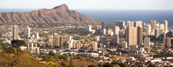 |
 Waikiki
and part of downtown Honolulu, with Diamond Head in the background, from
Tantalus Drive, an unnumbered scenic drive ultimately ascending to about
2000 feet above Honolulu. (September 1999) Waikiki
and part of downtown Honolulu, with Diamond Head in the background, from
Tantalus Drive, an unnumbered scenic drive ultimately ascending to about
2000 feet above Honolulu. (September 1999)
|
 |
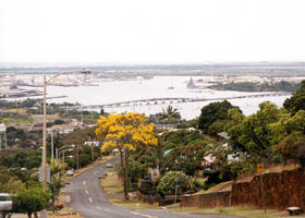
Another view
of downtown Honolulu, this one from the north shore of Sand Island, off
state route 64. (September 1999)
|
 Near the east end of
Interstate H-1, the unglamourous interior of the Diamond Head crater. Diamond
Head was long used as the Army's Fort Ruger (with cannons firing from the
inside over the crater rim to bombard targets offshore). It still houses
a National Guard base, as well as a parking lot for hikers to the Diamond
Head summit. Note the one-lane Kahala tunnel through the crater rim, on the
right, which is the entry point for both base traffic and tourists (there is a second one not in this photo, the Kapahulu tunnel -- closed, but proposals have been made to reopen it, as part of a plan to move visitor parking outside the crater). The need to link the military facilities at Diamond Head to others elsewhere in Oahu was part of the
stated justification for a network of Interstate highways on the island. (May 2000) Near the east end of
Interstate H-1, the unglamourous interior of the Diamond Head crater. Diamond
Head was long used as the Army's Fort Ruger (with cannons firing from the
inside over the crater rim to bombard targets offshore). It still houses
a National Guard base, as well as a parking lot for hikers to the Diamond
Head summit. Note the one-lane Kahala tunnel through the crater rim, on the
right, which is the entry point for both base traffic and tourists (there is a second one not in this photo, the Kapahulu tunnel -- closed, but proposals have been made to reopen it, as part of a plan to move visitor parking outside the crater). The need to link the military facilities at Diamond Head to others elsewhere in Oahu was part of the
stated justification for a network of Interstate highways on the island. (May 2000)
|
 |
|
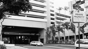
| "Don Ho Street"
in Waikiki, a dinky little (about 500 feet) private service road for the
Royal Hawaiian hotel complex. Don Ho (1930-2007) didn't even perform there in his last years,
having moved his shows to the Waikiki Beachcomber. (May 2000)
See my rant on why Don Ho should have a
freeway (or at least a highway) named for him.
|
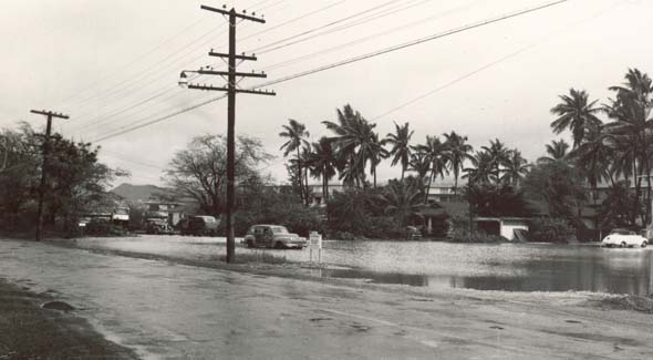 |
Ala Moana Boulevard (now state route 92), near Hobron Street on the west side of Waikiki, after a rainstorm in January 1950. This photo reportedly was taken facing northwest, toward downtown Honolulu, with one of the signs in the background advertising the Tradewinds apartments in the background. Next time I'm in Hawaii, I'll try to take a photo of the same place as it is today, but I assure you that neither the road (now much wider and far more congested) nor the surrounding area looks anything like it did in 1950. (Photo courtesy of Goro Sulijoadikusumo, of Hawaii DOT)
|
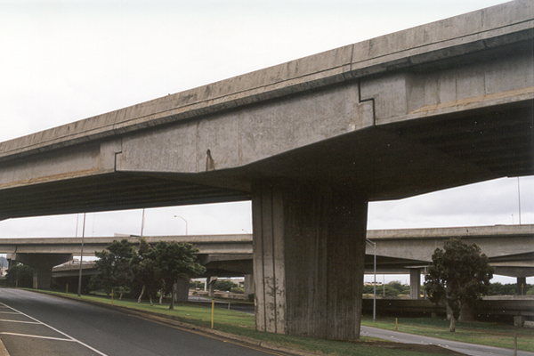
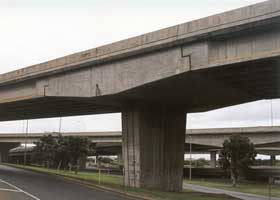
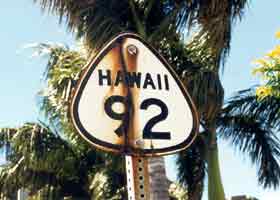
A distinctive hammerhead
pier on the bridge from eastbound Interstate H-1, at exit 18B, to Dillingham
Boulevard (former state route 90) over the westbound Nimitz Highway (state
route 92). The east end of the Interstate H-1 Airport Viaduct is in the
background. (November 2001) |
|
|
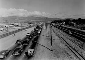
 A 1951 photo,
showing the Kamehameha and Nimitz Highways (which later became, respectively,
state routes 90 and 92), on parallel alignments north of the airport, toward
downtown Honolulu. The Kamehameha Highway (six-lane divided highway, left of the tracks) came first. The parallel Nimitz Highway (four-lane undivided highway, right of the tracks), originally called "Honolulu-Pearl Harbor Road," was built during World War II to carry the added traffic from new military facilities along the waterfront, and separate military from civilian traffic. These two highways were ultimately combined into a widened, divided Nimitz Highway, with Interstate H-1's Airport Viaduct built overhead. (Photo courtesy of Goro Sulijoadikusumo, of Hawaii DOT) A 1951 photo,
showing the Kamehameha and Nimitz Highways (which later became, respectively,
state routes 90 and 92), on parallel alignments north of the airport, toward
downtown Honolulu. The Kamehameha Highway (six-lane divided highway, left of the tracks) came first. The parallel Nimitz Highway (four-lane undivided highway, right of the tracks), originally called "Honolulu-Pearl Harbor Road," was built during World War II to carry the added traffic from new military facilities along the waterfront, and separate military from civilian traffic. These two highways were ultimately combined into a widened, divided Nimitz Highway, with Interstate H-1's Airport Viaduct built overhead. (Photo courtesy of Goro Sulijoadikusumo, of Hawaii DOT)
|
 |
 |
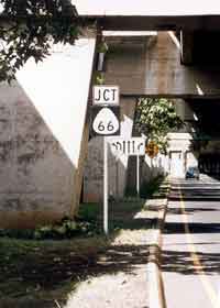
On the westbound
lanes of the modern-day Nimitz Highway, under the Interstate H-1 Airport
Viaduct, Hawaii has its own set of "route 66" signs at the junction with
Puuloa Road. Oddly enough, there are no such signs on Puuloa Road itself,
because it has long been renumbered as state route 7310, after the completion
of H-1 made that rather than Puuloa Road the main route to the airport
from Oahu's freeway network. I guess Hawaii's sign thieves aren't as taken
by the "route 66" mystique as are mainlanders. (November 2001)
|
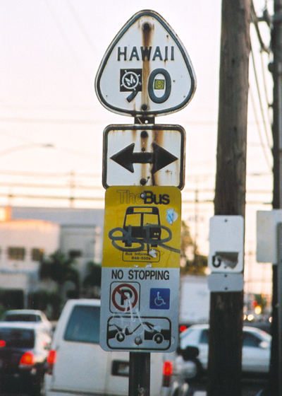
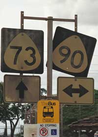
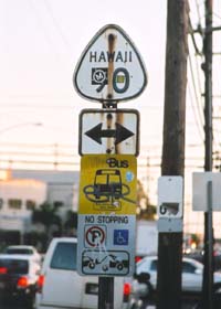
In Pearl City,
a bus stop marker for Oahu's "TheBus" system, by far the best bus system
on the islands, and the only one with service frequent and extensive enough
to be a plausible alternative for most tourists to renting a car. The route
signs above the bus stop marker (which have since been
removed) are outdated -- the cross street identified
as route 90 (part of the Kamehameha Highway) long ago became route 99,
while the roads identified as route 73 (Waimano Home Road/Lehua Avenue)
have long been removed from the state highway system and are now unnumbered
county roads. (November 2001)
|
An even
older cutout-style route sign, on the westbound Nimitz Highway west of
downtown Honolulu, next to a K-Mart. While this one apparently came down
after I took this photograph in September 1999 (and others have been
disappearing, on Oahu and other islands, in recent years), others like it (including
some for routes that have since been renumbered) might still be found elsewhere
on Oahu if you roam enough off the main highways.
|
|
|
Another cutout still standing (at least as of May 2005), on southbound Kalihi Street (state route 63) at its intersection with Dillingham Boulevard (former state route 90), west of downtown Honolulu.
|
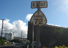
Another cutout, on eastbound Laulima Street in downtown Aiea, in a place I hadn't expected one, but spotted in August 2007 by a local resident researching the area's history. Her find pointed out to me that before the construction ca. 1968 of an interchange between the Kamehameha Highway and Moanalua Road (now Moanalua Freeway), Laulima Street was the connection between the two roads, and also part of route 72 before that route (now existing only in Oahu's southeastern corner) was truncated by the construction of Interstate H-1 and the renumbering of the Moanalua Freeway. (Photo courtesy of Arlene Ching)
|
|
 |
 |
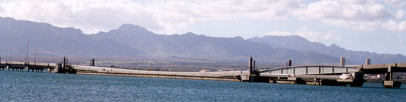
An overview
of the Admiral Clarey fixed-span/retractable floating span bridge between
Ford Island on the Pearl Harbor naval base and the rest of the base, from
Aiea Heights to the northeast. Until the bridge opened on April 15, 1998,
Ford Island -- which has battleship and other large-ship docks, a small
airfield, and officer housing including the home of the Commander in Chief
for the Pacific Fleet -- was accessible from the rest of the base only
by boat. The retractable pontoon allows the largest, tallest, and widest
(navigation channel is 650 feet wide, world's largest for an openable span)
warships to navigate freely around Pearl Harbor as needed. (May 2000)
|
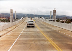
The Ford Island
bridge roadway, on the concrete retractable pontoon, looking eastward toward
the transition span between the pontoon and the elevated fixed span. The
transition span can be tilted upward, so the pontoon can be pulled under it (and part
of the fixed span) if the Navy needs to clear the navigation channel. Because the bridge
is entirely within the naval base, it is not part
of the state highway system, and is closed to most civilians. However,
trolleys taking visitors on tours of the decommissioned battleship U.S.S.
Missouri (now permanently docked at Ford Island) are allowed to use the
bridge. (October 1999) |
 |
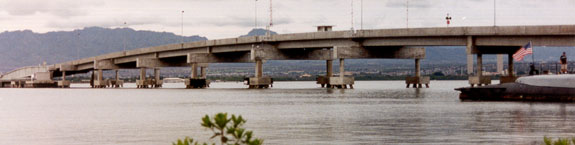
 The photos above and below are of, respectively, the pontoon and transition
spans, and the fixed span to the east of the pontoon (taken from the boat
ferrying tourists to the U.S.S. Arizona, and the U.S.S. Arizona visitor
center). The westernmost six piers of the fixed span are spread wider than the
others, to make room for the pontoon when it is retracted after the transition
spans are lifted. The total length of the bridge is about 4700 feet (950
feet for the retractable concrete pontoon). (Both photos September 1999)
The photos above and below are of, respectively, the pontoon and transition
spans, and the fixed span to the east of the pontoon (taken from the boat
ferrying tourists to the U.S.S. Arizona, and the U.S.S. Arizona visitor
center). The westernmost six piers of the fixed span are spread wider than the
others, to make room for the pontoon when it is retracted after the transition
spans are lifted. The total length of the bridge is about 4700 feet (950
feet for the retractable concrete pontoon). (Both photos September 1999) |
|
See also a page on a Navy website with photos of maintenance openings and mechanisms of the Admiral Clarey floating bridge.
Go to the previous or next parts of the Hawaii Highways road photos collection:
or directly to other parts:
Overview · Introduction
· Interstate H-3 · Interstate H-1 · Other Oahu East
Kuhio Highway · Other Kauai
· Hana Highway · Piilani
Highway
Kahekili Highway · Other
Maui · Lanai/Molokai · Kalawao County
Saddle Road · Observatories Roads · Lava Closures · Red Road
Waipio Valley · Other
Big Island
or to other sections of the Hawaii Highways site:
Comments, etc.? Please e-mail me.
© 1999-2007 Oscar Voss. |