| PAGE 3
Route numbers and names |
| PAGE 3
Route numbers and names |
Table of Contents for this page:
3.1 What is the route numbering system used in Hawaii?
Hawaii has a fairly logical route number system:
a. Route numbers are "clustered" by island:While there is a definite pattern to route designations in Hawaii, the state and county transportation departments do not always remove signs showing obsolete route numbers not consistent with the rules outlined above. Adventurous travelers can sometimes find rusted old cutout-style route shields, on roads that were long ago removed from the state highway system, or that were later renumbered (though as far as I know there are none on Kauai, Lanai, or Molokai, and they are increasingly hard to find on the other islands). The route lists on this site note some of the places where old route signage might still be found.Highways
are on the island of Hawaii (a/k/a "the Big Island").
Highwaysare on the island of Maui.
Highwaysare on the islands of Molokai and Lanai (Maui used to have 4x routes as well).
Highwaysare on the island of Kauai.
Highwaysto
and Interstates
are on the island of Oahu.
There are no state or county highways on Niihau (the lightly-populated, wholly privately-owned "Forbidden Island," notorious for putting the unwelcome mat out for tourists), or Kahoolawe (uninhabited, long used by the military as a gunnery range, and so sometimes dubbed the "Target Island;" still being reclaimed by native Hawaiian organizations, and essentially off-limits to the general public). There are two unpaved highways on Kahoolawe, numbered K-1 and K-2 (K-1 is on a roughly west-east route atop the ridge that bisects the island; K-2 is a much shorter spur north from the middle of K-1).
b. State highway route numbers have two, three, or four digits. (There are no single-digit route numbers.)
1. Two-digit routes are assigned to routes in the primary highway system.c. County highway route numbers follow the pattern outlined above for state secondary routes, except Maui County route 31 (a notoriously bad county road, that acquired its route rumber before its link to state route 31 was severed). Also, where county highways are marked with route shields (they often are not, though sometimes milemarkers will indicate the numbers of unshielded county routes), the shields are usually identical to those on state highways. Most or all of the exceptions are on Maui island, where the newer county route markers are slightly different from state markers, and there are some other kinds of oddball county markers. In addition, many unsigned county roads in urban areas (not shown on this site's route lists) were assigned four-digit Federal Aid Urban route numbers.2. Secondary state highways get three-digit numbers. The first two digits will indicate the primary highway, if any, to which the secondary route is related. In some cases, there is no related route, but the secondary route used to be a primary route, or at least was numbered like one -- for example, state route 130 on the Big Island started off as route 13 at statehood (but still gets trashed by lava flows, even after losing its "unlucky" original number), while route 750 on Oahu was originally route 75. Sometimes a secondary route is an extension of a primary route -- for example, the Hana Highway on Maui starts off as route 36, then becomes route 360 (at about the same point where the road becomes twistier and more interesting). Where the third digit is not a zero, the secondary route is usually a direct or indirect loop or spur from a primary route, rather than a continuation of a primary route, or a former primary route. For example, Maui's route 377 is a loop from route 37, while route 378 to Haleakala National Park is a spur from route 377.
All the state highways on Lanai and Molokai are secondary routes, with three-digit route numbers.
3. There are also some state routes with four-digit route numbers. Most of them are on Oahu, though there are a few on Maui and the Big Island. Those often are for minor roads that would not ordinarily warrant inclusion in the state highway system, but were included because they received special Federal funding. Many of the four-digit routes are associated with the numerous military installations on Oahu. Most four-digit routes are unsigned. Aside from following rule (a) above, there is no clear pattern to the assignment of 4-digit route numbers.
4. It is not unusual for state routes to be signed with numbers different from the number assigned in the official route log. Maui used to have several four-digit routes signed with two- or three- digit numbers (knocking off one or two zeros at the end), though the state is now bringing the signage into closer alignment with the official route numbers.
3.2 Why are there numbered county highways, in addition to (and marked just like) the state highway system?
Hawaii started off with a single numbered highway system, with a somewhat disorganized jumble of both state- and county-maintained roads (as well as a few military roads). It was not until the late 1960s that discrete state and county highway systems were established. In the process, the old route numbers were generally carried over to the new systems (some routes were renumbered, and many minor roads lost their numbers altogether), along with their route signage.
Many of the numbered county routes that now exist are remnants of the unified route number system from the early post-statehood years. Some counties augmented the numbered routes they inherited with new routes built under the Federal Aid Secondary County highway program. Maui County also slapped route numbers on some existing county roads never in any Federal-aid system, particularly on the north central part of Maui island. Both groups of newer county routes generally have minimal route signage, with milemarkers indicating the route numbers, but no route markers.
3.3 Why are some routes classified as "former" as opposed to "current" state or county routes, on your route lists?
This is kind of tricky, since there are a lot of roads throughout the islands that are shown on various maps as numbered highways, with varying degrees of route signage (from fully signed and milemarked, to no visible indication that the road ever bore route numbers) and of "official" status (for example, Kauai County has a well-signed system of numbered major county routes in addition to the state routes and its extensive network of unnumbered county roads, while Honolulu County says it does not maintain any route number system at all for its county roads).
I followed these basic guidelines:
a. If a road appears, and is assigned a state or county route number, on Hawaii DOT's most recent Designated Ways and Traveled Ways ("DW&TW") map for the relevant island, or a current official county route map (such as Hawaii County's), the route lists treat it as a current state or county route, whether or not the road is signed.As is indicated by the comments in some listings about the quality of route signage and of the evidence of the route number assignment, the classification of some routes involved close judgment calls. In particular, some "former county routes" (particularly on Oahu) may still in some sense remain "officially" designated numbered county routes, even if the county government pays little or no attention to the number designations.b. If a road appears, and is assigned a state route number (including a Federal Aid Primary or Federal Aid Secondary route number) on any historical official route map or planning document, such as a Hawaii DOT General Highway Map, but is not on the current DW&TW map, and there is no indication that the road later became a numbered county highway, the route lists treat it as a former state route, even if some stray route signage remains (which I note in the route lists where I know it exists). Because the Federal-aid route systems in Hawaii up to at least the late 1960s did not differentiate between state- and county-maintained routes, all Federal-aid routes from that era that did not remain in the Federal-aid system are classified in this site's route lists as "former state routes," even where a Federal Aid Primary or Federal Aid Secondary route had always been under county jurisdiction.
c. If a road appears in historical post-statehood Hawaii DOT planning documents as a numbered Federal-aid route (either primary or secondary) under the jurisdiction of the U.S. Department of Defense, it is treated as a "former military route," whether or not it is still under military jurisdiction. There are two such routes on Oahu still under military control (parts of former route 78, and former route 782), and one short former military route on Maui (part of route 37, apparently no longer under military control, but never becoming a numbered state or county route). See item 3.11 below for a discussion of a World War II-era system of Federal routes on Oahu, not included in this site's route lists.
d. If a road appears, and is assigned a county route number (including a Federal Aid Secondary County route number) on any historical official route map or log, such as a Hawaii DOT General Highway Map, or Maui County's route log (yes, it's from 1981, but officially still valid), and absent evidence that the route designation has been formally removed, the road is generally treated:
1. as a current county route if any route signage remains (even if incomplete, faded, or rusted);e. The many non-primary or -secondary roads (particularly in Honolulu) assigned four-digit "Federal Aid Urban" route numbers, but omitted from DT&TW maps, generally are not shown on the route lists at all. None of these local, county-maintained roads bear any route number signage, and their route numbers rarely appear on any unofficial maps, so for simplicity's sake I do not list them.2. as a former county route if no route signage remains.
3.4 How did Hawaii's route number system evolve into its present form?
Until shortly before Hawaii became a state, the territory's highways had no conspicuously signed route numbers. The roads that were part of the Federal-aid highway network did have assigned numbers (with some numbers duplicated for highways on different islands), but any Federal-aid route markers were much smaller than conventional route markers, and apparently were placed only at the termini of Federal-aid project segments. They seem to have been intended only for the use of highway department personnel rather than motorists, and were not shown on any published maps. The only exception was the temporary wartime Federal route system (bearing no correspondence to the Federal-aid route assignments) on Oahu, discussed in more detail in item 3.11 below.
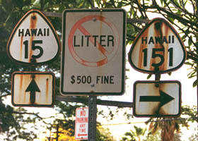
In a "great renumbering" circa 1955, the U.S. Bureau of Public Roads completely renumbered the Federal-aid routes in Hawaii, to adopt essentially the same system now in use today. This system did not differentiate between state- and county-maintained routes. Also, while the Federal route assignments followed the pattern outlined above of two-digit numbers for primary routes and three-digit numbers for secondary routes, the secondary routes assigned three-digit numbers ending in "0" were generally signed with only the first two digits (for example, Federal-aid secondary route 150 on the Big Island was signed as route 15, while 151 was signed with all three digits). With this modification, the new route numbers started showing up on maps just before statehood, and on road signs about that time as well.
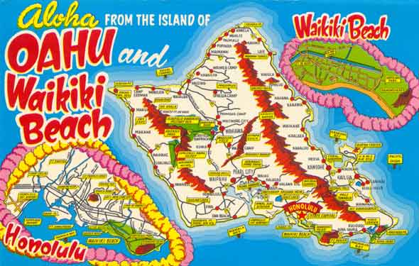
This postcard my father sent me from Hawaii in 1966, on his way to his second tour of duty in Vietnam, shows the pre-Interstates numbered highway network on Oahu (with insets for major streets in downtown Honolulu and on Waikiki), after the "great renumbering" and before the next round of renumbering discussed below. Click on the image below for a zoomable detailed map showing most route numbers and some route names (about 1 MB download, requires Adobe Reader, best viewed at 800% magnification):
In the late 1960s, a "lesser renumbering" was implemented statewide. Many minor routes became numbered county routes (with some numbers changed in the process), or lost their route numbers altogether. The routes assigned to the county systems that had been in the Federal-aid highway system became Federal-Aid Secondary County routes. Also, the numbers assigned by the state to secondary routes, and shown on road signs and maps, were conformed to the Federal-aid route numbers, so that all secondary routes (with the oddball exception of county route 31 on Maui, which then was connected to primary state route 31) were consistently numbered as three-digit routes. Two Federal-aid routes on Oahu with 4-digit route numbers likewise were given new three-digit numbers, to bring them into line with the rest of the number system. Some primary routes in northern and western Oahu were renumbered with new two-digit numbers.
At some point thereafter (probably in the 1990s), the state started assigning new 4-digit route numbers for some minor routes, the majority of them on Oahu near military bases. Some but not all of these routes are signed with route number markers.
Also, there were two island-specific major number system changes since the 1960s. At some point, Honolulu County abandoned its numbering of county routes. Going in the other direction, by 1976 Maui County decided to establish new route numbers for some roads, on the central part of Maui island, that had never been part of any Federal-aid route system, as well as one road on Lanai that had long ago been part of a Federal-aid route. These Maui County routes are usually signed poorly if at all, but they remain "official" as far as I know.
3.5 When I asked a Hawaiian a question about "route 99," all I got was a blank stare. How much do Hawaiians pay attention to route numbers, anyway?
Not much. Hawaiians usually refer to highways by name, rather than number, so it's mostly tourists who take advantage of Hawaii's sensible route numbering system. (The route numbers are a big help to tourists and other newcomers, since route numbers are more conspicuously signed on most highways than route names.) The only exceptions are Hawaii's Interstates H-1 through H-3, which until 2002 had no other names except for the eastern third of H-1 (Lunalilo Freeway, a name that stretch of freeway acquired before it was added to the Interstate system). They thus are generally called Interstate H-1, etc. (not, thankfully, "I-H-1"-- maybe they too will come to be known by name rather than number, though some of the new names like "Queen Liliuokalani Freeway" will still be tongue-twisters for the tourists). The route lists on this site accordingly provide names, as well as route numbers, for most of the highways they cover.
For some of the longer routes, there is at best a loose correspondence between name and route number. For example, the Kamehameha Highway on Oahu starts with a little disconnected snippet (0.10 mile-long state route 7401) east of Interstate H-1 exit 18, then disappears under H-1's Airport Viaduct (it used to run parallel to the Nimitz Highway there, but now the two routes have been combined into one really wide divided highway, named the Nimitz Highway and signed as state route 92), then re-emerges as route 99 at the other end of the viaduct west of the airport, then turns into route 80 through Wahiawa, then back to route 99 (after route 99 detours around Wahiawa over two other roads), then becomes an unnumbered highway through Haleiwa, then continues as route 83, then goes through one more number change and back again in Kaneohe before finally ending west of Kailua as route 83. On the Big Island, 122-mile-long route 11 (the state's longest highway) goes through five name changes between its start in Hilo and its end in Kailua-Kona. The shorter route 19 between those cities around the other side of the island includes part or all of ten named roads and highways (Kuhio Street, Kalanianaole Avenue, Kamehameha Avenue, Pauahi Street, Bayfront Highway, Hawaii Belt Road, Mamalahoa Highway, Lindsay Road, Kawaihae Road, and Queen Kaahumanu Highway).
3.6 Are there any multiplexed routes in Hawaii?
There are no routes, either state or county, signed with two different route numbers. Hawaii DOT seems to hate multiplexes, and indeed the last time there was one (between routes 63 and 83 in Kaneohe, in the 1960s), Hawaii DOT eliminated it by renumbering part of one of the overlapping routes. However, there are a few routes that carry one number on paper but are signed only with a different number, such as route 201 on the Big Island (temporarily signed only as part of state route 200, until the state builds a new alignment for route 200 and transfers route 201 to sole county jurisdiction). There is also a multiplex about 0.3 miles long in Kailua-Kona on the Big Island, where part of Hualalai Road (unsigned county route 182) was realigned onto part of the new Queen Kaahumanu Highway (part of state route 11 at that point, and part of state route 19 north of Kailua-Kona).
3.7 Are there any bannered routes in Hawaii?
There is only one current bannered route (i.e., with route markers indicating them to be "alternate," "business," "bypass," or "truck" routes) in Hawaii, "by-pass" route 32 in downtown Wailuku on Maui. Maui used to have three and possibly four short bannered "by-pass" routes to divert traffic around downtown Wailuku; some of their rusted old route markers remained until sometime after November 2001 (the route markers have since vanished, but the rest of the sign assemblies remain). Part or all of two of those old routes apparently are included in the current Wailuku bypass.
Kauai has some temporary bypasses of particularly congested stretches of state highway, built on former cane haul roads or stitched together from existing county roads. They have no "by-pass" route markers or similar signage (as far as I know), though the Kapaa bypass was recently assigned route number 5600 in Hawaii DOT's inventory. Maui also has a short "mini-bypass" part way around downtown Paia, assigned route number 3600 (but I know that number is unsigned).
3.8 Does Hawaii allow duplication of route numbers between the Interstate, state, and county route systems?
There are certainly many routes which change from state to county jurisdiction, but keep the same route number, such as Kahekili Highway (route 340) in northwestern Maui, and route 200 on the Big Island (county route in Hilo, state route west of the Hilo urban area boundary). There's also the Piilani Highway in south Maui, which used to be a continuous route, but now is split into two disconnected roads, with the western segment under state jurisdiction and the eastern segment under county jurisdiction. However, with the (kind of) exception of Interstate H-201 on Oahu and "secret" route 201 on the Big Island, there are no unrelated routes in Hawaii assigned the same route number. The numbering scheme outlined above, where Interstates normally get single-digit numbers, and separate route number blocks are reserved for other routes in each county, minimizes duplication.
3.9 What are the lowest- and highest-numbered routes in Hawaii?
The lowest-numbered state route in Hawaii, not counting the Interstates, is state highway 11 on the Big Island. (There may once have been a route 10 there, though I doubt it. There also used to be proposed interisland ferry routes assigned state route numbers 6-10, though the short-lived ferry system serving some of those routes never carried auto traffic.) The highest-numbered state route that I know to be signed (albeit minimally) is state route 7310 on Oahu. A new highway recently completed in southwest Oahu, Kualakai Parkway (formerly North-South Road), is assigned state route number 8930, though that number may not be signed. Including unsigned routes, the highest number is for the new state route 8955, Coral Sea Road, also in southwest Oahu.
There is a short county route on Oahu, 0.12-mile long Notley Street between Middle Street and an entrance to the Fort Shafter Army base, with five-digit route number 74140. That route, and part of Middle Street (county route 7414), are included in Hawaii DOT's route inventory, but apparently only because they are part of the National Highway System (normally limited in Hawaii to state routes) to help connect the Army base to the rest of the highway system. Since Honolulu County does not maintain a conventional route numbering system, I treat both route numbers only as internal county inventory numbers (even though also technically in Hawaii DOT's internal inventory), and exclude them from this site's Oahu route lists.
3.10 Are there any suffixed routes in Hawaii?
Just the very short spur routes 32A and 32B to the Hawaii DOT-operated harbor in Kahului on Maui, and also short route 36A to the Kahului airport.
3.11 One old map suggests that there might have been a system of U.S. routes in Hawaii before it became a state. Do you know what the story is on that?
There was no U.S. route number system on Hawaii while it was still a territory, though there was a system of Federal routes on Oahu during World War II that was marked with shields similar to standard U.S. route shields.
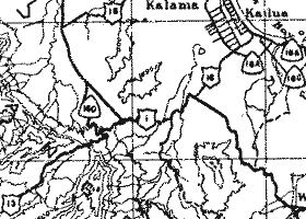
This question is usually prompted by the Hawaii map in the Texaco/Rand
McNally "49-State Road Atlas" from 1959 (in the brief interval between
Alaska's and Hawaii's admissions to statehood), shown in the first map
excerpt below. That map's route numbers and shield shapes happen to roughly
correspond to those on an Army Day souvenir map of Oahu from 1946, part
of which is in the second excerpt below.
| 1959
map |
 |
| 1946
map |
 |
However, Hawaii's territorial highway department, in a letter to Rand McNally in August 1959, objected (after prodding from competing mapmaker H.M. Gousha) that the above Rand McNally map was seriously out of date, and that any "U.S. Route marking system" was "in effect [only] during World War II and was officially abandoned in 1945." That is consistent with AASHTO records indicating that no U.S. route numbers were ever officially approved for Hawaii, and by back issues of its American Highways magazine (the back cover of which showed examples of state route shields) which indicate that at least as early as 1952, route shields in Hawaii territory were identical to the old post-statehood cutout-style white route shields (resembling the wartime secondary route marker shown below).
Bureau of Public Roads files at the National Archives confirm that there was a temporary Federal route number system on Oahu, used during World War II. As noted above, Hawaii highways were previously unnumbered, except perhaps for some inconspicuous Federal-aid route markers (too small to be useful for motorists, and probably placed only for reference by highway department personnel). That was fine with local residents familiar with the road network and the marked road names, but a real headache for the troops arriving from the mainland as the United States ramped up its military defense of the islands before the war. Tired of his troops getting lost all the time on roads marked only with Hawaiian names, Major General William H. Howard, Commanding General, Schofield Barracks, proposed a numbered highway system for Oahu in July 1940. The territorial highway department started carrying out this project in September 1941, with signs installed sometime the following year (after some delays, following the attack on Pearl Harbor, getting supplies from the mainland). The highway department's plans called for a system of primary routes marked with shields, and secondary routes marked with "teardrop" markers. The route numbers in those plans correspond closely to the routes indicated on the Army Day map excerpted above, and to a lesser extent the Rand McNally map above. (Bureau of Public Roads, U.S. Department of Commerce, project files for FAP(DEC) 52-A, records group 30; courtesy of the National Archives and Records Administration - Pacific Region, San Francisco.)
Below is a photo taken in November 1944 (click on the photo for a larger image), showing both primary and secondary wartime route markers, apparently at the junction of what was then Waianae Road (wartime primary route 2/Federal Aid Primary route 40; now part of the Farrington Highway, at this location part of former state route 90) and Ewa Connection (wartime secondary route 211; now Old Fort Weaver Road, former state route 760). The primary route marker resembles an old-style U.S. route number, with "Hawaii" above the number. The "teardrop" shape of the secondary marker was ultimately adopted, with minor modifications, for standard non-Interstate route markers in Hawaii post-statehood.
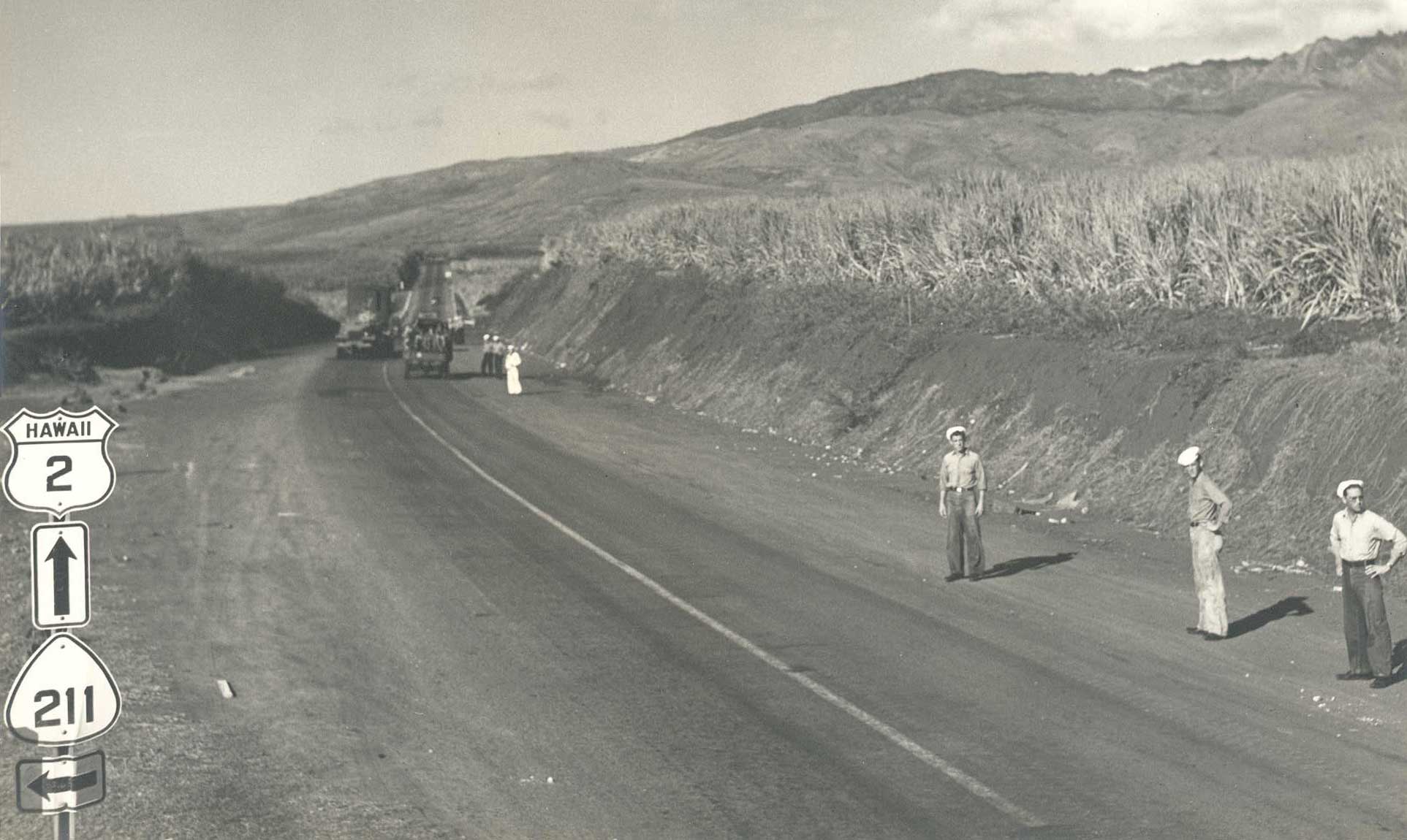
(Photo from Hawaii DOT archives, courtesy of Goro Sulijoadikusumo.)
The 1946 Army Day map excerpted above can be viewed in its entirety here, for a detailed overview of the entire wartime numbered route network on Oahu. (1.24 MB download, requires Adobe Reader.) The network was extensive in the rural areas outside Honolulu, and included lots of unpaved roads, many of which are now impassible or otherwise closed to the general public.
3.12 What route marker styles were used in Hawaii post-statehood?
See the Hawaii Road Signs collection for photos and other information on the current route marker style for state and most county highways, and older styles (including the cutout-style shields used in the first years after Hawaii's admission to statehood, and still found on some highways).
 to Page 1: Table of contents,
"About this site" |
 to Page 2: "Tips for Tourists"
 |
 to Page 4: Interstates
and other freeways |
Links to main page and other parts of Hawaii Highways site, and related sites:
Comments, more questions, etc.? Please e-mail me.
© Oscar Voss. Last updated December 2010.
