| Hawaii
Highways road photos -- Other Maui
(Maui part 4 of 4 -- other Maui
parts:
Hana
Highway · Piilani
Highway · Kahekili
Highway)
Twenty road photos, for western Maui except for the northwest coast
(covered by the preceding Kahekili Highway
photos page), as well as the road to the Haleakala volcano summit,
and other places in central Maui. I took all the photos below on my several
visits to Maui, except as noted below for several photos contributed by others.
Note: In case you want more detail, clicking some of the photos
below (for now, mainly those from my 2001 trip, and some of the photos
submitted by others) will call up enlarged, higher-quality (less .jpg compression)
versions. Those alternate versions have larger file sizes, so please be
patient while they download.
 |
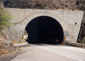 |
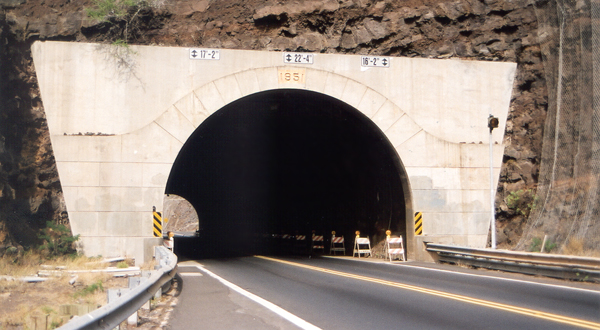
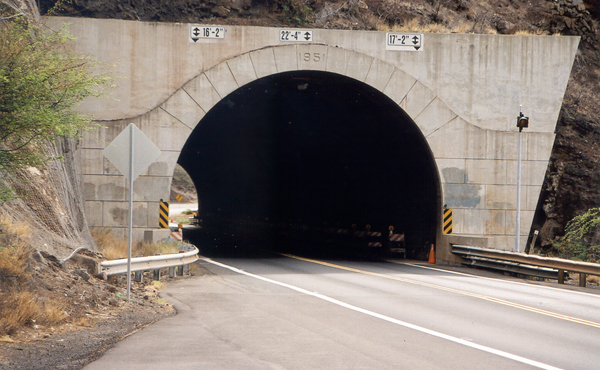
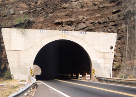
 The east
and west portals, respectively, of the 318-foot-long Olowalu Tunnel at
mile 10.4 on the Honoapiilani Highway (state route 30), along Maui's southwest
coast west of Maalaea Harbor. Built in 1951, this is the oldest highway
tunnel in Hawaii. On the mauka (inland) side of each portal is wire netting
to keep rocks from falling onto the roadway. (Both photos November 2001;
contrast digitally enhanced on part of the photo above left) The east
and west portals, respectively, of the 318-foot-long Olowalu Tunnel at
mile 10.4 on the Honoapiilani Highway (state route 30), along Maui's southwest
coast west of Maalaea Harbor. Built in 1951, this is the oldest highway
tunnel in Hawaii. On the mauka (inland) side of each portal is wire netting
to keep rocks from falling onto the roadway. (Both photos November 2001;
contrast digitally enhanced on part of the photo above left)
|
 |
 |
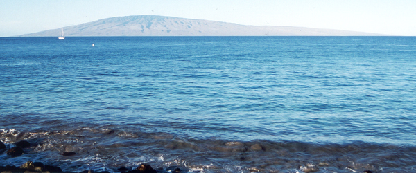
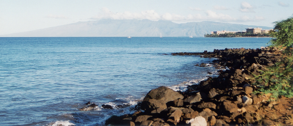
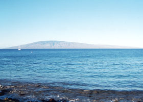
At mile 22.3
on the Honoapillani Highway north of Lahaina is a pullout with good views
of Lanai to the southwest (above left), and Molokai to the northwest (above
right). (Both photos November 2001)
|
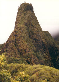
 The Iao Needle, the
top of which is about 2250 feet above sea level, at the end of county route
320 in the Iao Valley just west of Wailuku. Aside from the prominent landmark,
Iao Valley is best known for a decisive 1790 battle in Kamehameha the Great's
conquest of Maui, where his forces cornered and slaughtered much of the
Maui army. (October 1999) The Iao Needle, the
top of which is about 2250 feet above sea level, at the end of county route
320 in the Iao Valley just west of Wailuku. Aside from the prominent landmark,
Iao Valley is best known for a decisive 1790 battle in Kamehameha the Great's
conquest of Maui, where his forces cornered and slaughtered much of the
Maui army. (October 1999)
|
|
 |
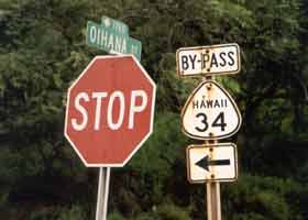 |
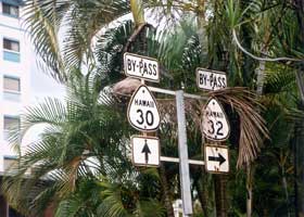
I didn't
see any old "by-pass" route shields, like these in Wailuku, anywhere else
on the islands (though Kauai currently has some temporary bypass routes,
not marked with route shields). The photo on the left was taken on Wells Street,
facing west, at Kimpopo Street. Bypass 30 joined main route 30 three blocks
to the west where Wells Street ends at High Street, and bypass 34 two blocks
to the east at Waiale Drive; bypass 32 was only one block long, to the
junction of Kimpopo Street and West Main Street. The photo on the right
was taken at the bottom of the Oihana Street off-ramp from eastbound West Main
Street to East Main Street, which was part of the old 34 bypass, connecting
route 32 to what was then the main route 34 (now state route 340) in Kahului.
All three of these bypass routes were within blocks of the main routes.
These sign assemblies, plus a few similar ones elsewhere in downtown Wailuku, were still
in place in June 2005, only with the route markers missing. (Both photos November 2001)
|
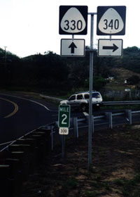
North of downtown Wailuku,
the easternmost segment of the Kahekili Highway meets state route 340 (Waiehu
Beach Road to the right, heading back to Kahului, is now signed as state route 3400). Notwithstanding the sign assembly,
county route 330 ends here; the Kahekili Highway continues straight ahead,
but as a segment of state route 340 (and then later turning into the narrow
and twisty county-maintained part of the Kahekili Highway). (November
2000, photo courtesy of Kurumi.)
|
|
 |
 |
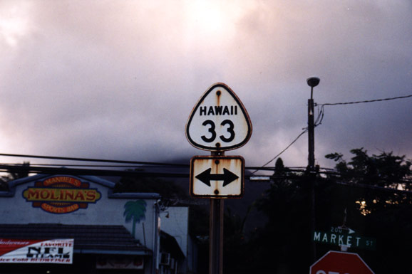
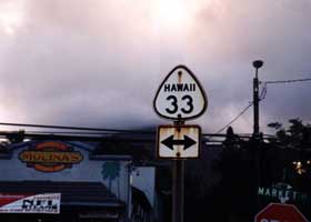
| Market
Street through downtown Wailuku, another segment of county route 330, has
this old cutout shield along the way, from when it was part of state route
33 back in the 1960s. (November 2000, photo courtesy of Kurumi.) |
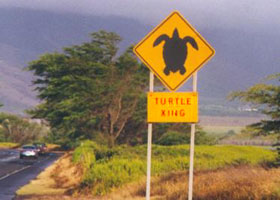
This "Turtle
Crossing" sign was on North Kihei Road (state route 310) on the south Maui
coast, on a major turtle migration path between the shore and the Kealia
Pond wildlife refuge. The sign was no longer there when I revisited Maui in spring 2005.
(March 1999, photo courtesy of Mark
and Sue Pelletier, contrast enhanced on sign)
|
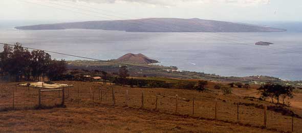 |
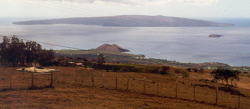
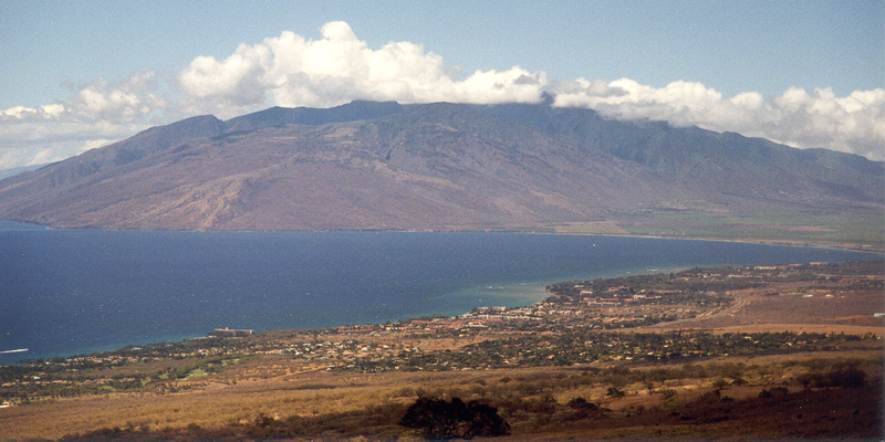
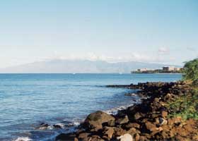
 Two
scenic views from Sun Yat Sen Park, a small roadside park at mile 18.5
near the east end of the Kula Highway (part of state route 37), about 2400
feet above the south Maui coast. The photo above shows two islands offshore:
Kahoolawe (the larger one), uninhabited after decades of use as a bombing
range, but being restored to civilian use; and Molokini (the smaller one),
a semi-circular island whose deep cove is a very popular snorkeling spot.
Also shown above, near the center on the shoreline, is the Pu'u Ola'i cinder
cone in Makena State Park. The photo below is of the west Maui mountains,
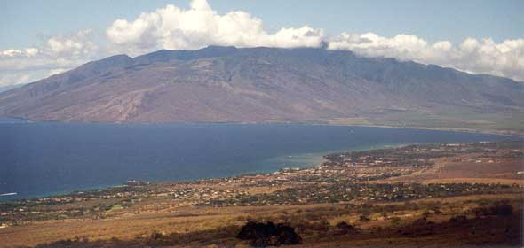
across Maalaea Bay. (Both photos November 2001) Two
scenic views from Sun Yat Sen Park, a small roadside park at mile 18.5
near the east end of the Kula Highway (part of state route 37), about 2400
feet above the south Maui coast. The photo above shows two islands offshore:
Kahoolawe (the larger one), uninhabited after decades of use as a bombing
range, but being restored to civilian use; and Molokini (the smaller one),
a semi-circular island whose deep cove is a very popular snorkeling spot.
Also shown above, near the center on the shoreline, is the Pu'u Ola'i cinder
cone in Makena State Park. The photo below is of the west Maui mountains,
across Maalaea Bay. (Both photos November 2001) |
|
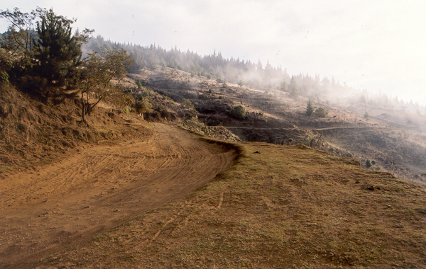
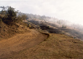
An unpaved segment
of Waipoli Road, high in upcountry Maui southeast of Kula, on the way to
Polipoli Spring State Recreation Area. (November 2001) |
|
|
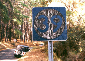
 I found
this ancient shield at the end of what is now county route 390, Olinda
Road, on Maui southeast of Makawao in October 1999. As far as I know, there are no route shields
like it anywhere else in Hawaii. I don't know whether this is another old
standard style for state route shields, or a county or territorial route
shield. I found
this ancient shield at the end of what is now county route 390, Olinda
Road, on Maui southeast of Makawao in October 1999. As far as I know, there are no route shields
like it anywhere else in Hawaii. I don't know whether this is another old
standard style for state route shields, or a county or territorial route
shield.
|
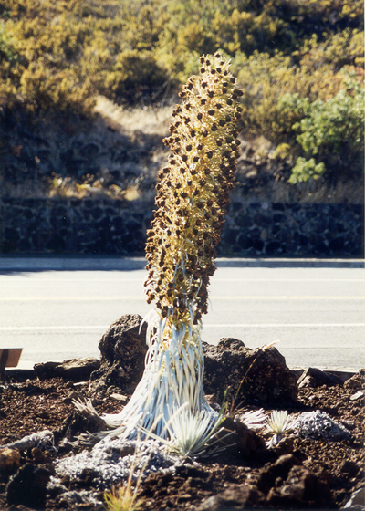
Next to Haleakala Crater
Road (at this point an unnumbered national park road, continuing from the
east end of state route 378), in front of the Haleakala National Park entrance
visitor center, is this silversword plant. That unique species is found
only in Hawaii at high altitudes, and sometimes hard to find in bloom like
this one. (May 2000) |

|
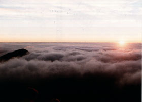 |
Sunrise over the Haleakala Volcano crater, at the visitor center (about
9740 feet altitude), unfortunately on a day when morning clouds filled
the crater, To join the crowd convening here for the sunrise, you need
to get up very, very early (like 3-4am). Many people try instead to be
up here for sunset, which is said to be also spectacular when the weather
cooperates. (May 2000)
|
 |
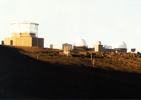 |
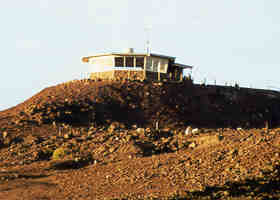
The two photos
above are of the Red Hill summit area within Haleakala National Park (the
Pu'u'ula'ula Overlook to the left, the Science Hill observatories to the
right). The road to the summit, Haleakala Crater Road, rises to an elevation
of about 10000 feet, and is the highest road on Maui. The summit itself
is at 10023 feet, Maui's highest point. (Both photos May 2000)
|
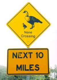
Near the
national park entrance, this "Nene Crossing" sign alerts visitors to watch out for those birds on Haleakala
Crater Road all the way to the summit. The nene are a goose species unique
to Hawaii, endangered by among other things their unfortunate habit of
walking across highways without looking both ways first -- as one local
wag put it, nene are not exactly the Einsteins of the bird world. (May 2005)
|
|
|
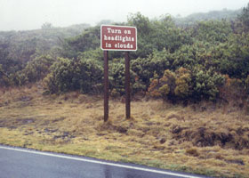
This National Park
Service sign on the downhill side of Haleakala Crater Road reminds travelers
to use their lights when the clouds drop below the summit, as they did
on this foggy day. (January 1999, photo courtesy of Teresa Frechette)
|
Go to the previous or next parts of the Hawaii Highways road photos
collection:
or directly to other parts:
Overview · Introduction
·
Interstate
H-3 · Interstate H-1
· Other Freeways
Other Oahu South · Other
Oahu West · Other Oahu East ·
Kuhio
Highway
Other Kauai · Hana
Highway · Piilani Highway
· Kalawao County
Saddle Road · Observatories
Roads · Lava Closures
· Red Road
Waipio Valley · Other
Big Island
or to other sections of the Hawaii Highways site:
Comments, etc.? Please e-mail me.
© 1999-2004, 2006 Oscar Voss. |