| PAGE 6
Other Topics |
| PAGE 6
Other Topics |
Table of Contents for this page:
6.1 Who has maintenance responsibility for roads other than designated Interstates and state highways?
This depends on the road in question, and can be confusing for some roads. In general, roads not in the state highway system are county roads. However, the state owns and maintains portions of some roads not designated as state highways, where they intersect with numbered state routes. Many other roads are also state-owned, maintained by the state Department of Transportation (not just its Highways Division, but occasionally its Airports and Harbors divisions), or the Department of Land and Natural Resources, among other state agencies. Moreover, the state Department of Hawaiian Home Lands owns some roads, but their maintenance is committed by law to the county governments. A few other roads are maintained by Federal agencies, such as the National Park Service or the Department of Defense. Also, there are many private roads open to the public, some of which are maintained by the counties, some not. Even for some roads in the state highway system, responsibility can be ambiguous (for example, a fatal accident on Saddle Road on the Big Island, which is designated as a state route but part of which was still owned by the county (most of it has since been replaced by a new state-owned road), generated lots of finger-pointing between lawyers for the state and the county about who was responsible for the problem found to have contributed to the accident, and the resulting damage award to the victim's family).
The route lists here generally do not address who owns, and/or is responsible for maintaining, specific roads not in the numbered state highway system. If you want to sue somebody over the design or maintenance of other roads in Hawaii, you're on your own.
6.2 What are the shortest and longest numbered highways in Hawaii?
The shortest numbered route is unsigned 0.03 mile-long state route 442 on Lanai, a short spur toward Lanai City from state route 440. I don't know whether it is signed, but it wasn't on my last visit in 2001. The shortest signed state route (unless route 442 turns out to be signed -- I know Hawaii's other mini-routes are unsigned) is state route 32A (Hobron Street) on Maui, at 0.41 miles. The longest numbered highway is state route 11 on the Big Island, at 122.09 miles.
6.3 What is the highest road in Hawaii, and the highest point in the state highway system?
The highest road is the Mauna Kea Access Road (also known, and signed, as John A. Burns Way), the access road to the University of Hawaii observatory complex atop Mauna Kea on the Big Island. It is not part of the state highway system, but rather is maintained by the University. The road tops out at about 13780 feet (just a little short of the summit at 13796 feet). While much of the road is unpaved and has a 15% grade, restricting travel to 4x4s, the uppermost four miles are paved so that vehicles don't stir up dust that would get into the telescopes, making this road the third highest paved highway, or highway of any kind, in the United States (after the toll roads to about 14160 feet at the parking lot below the summit of Mt. Evans in Colorado, and about 14110 feet to the summit of Colorado's Pikes Peak). The highway is open to the public without restrictions to the Onizuka Visitor Center at about the 9200 foot level. Above the visitor center, travel is restricted for safety reasons, and to avoid interference with observatory operations, but I was able to drive a 4x4 to the summit in one of the escorted observatory tours usually held on weekend afternoons, and on later vacations I took unescorted weekday afternoon drives up to the summit area.
The highest road with unrestricted public access, and which also is completely paved, is an unnumbered road to the National Oceanic and Atmospheric Administration weather observatory complex on the north slope of the Mauna Loa volcano on the Big Island. That road ascends above 11000 feet, though a gate keeps the general public from reaching the end of pavement at 11141 feet. The next highest such road is the road in Haleakala National Park on Maui, to the Red Hill summit of the Haleakala volcano, which begins where state route 378 ends at the park entrance, and just barely crosses the 10000-foot mark (at the parking area just beneath the Red Hill summit, which is at 10023 feet).
The highest point on the state highway system is Maui's Haleakala Highway (state route 378) where it ends at the entrance to Haleakala National Park, at an elevation of 6721 feet. Coming in a close second is Ala Mauna Saddle Road (state route 200) on the Big Island, as it passes over the Humuula Saddle (between the Mauna Kea and Mauna Loa volcanoes) at 6670 feet.
6.4 Are there carpool lanes on Hawaii's freeways and other major roads?
Hawaii DOT leans heavily on carpool (High Occupancy Vehicle) lanes to make the most of its freeway capacity. Much of Interstates H-2 and H-201 (Moanalua Freeway), and part of Interstate H-1, have lanes in both directions of travel subject to HOV-2 restrictions (single-occupant motorcycles allowed) in both the morning and afternoon rush hours. Another part of Interstate H-1 has not only HOV-2 carpool lanes, but also eastbound during the morning rush an HOV-2 "zipper lane" created with movable barriers out of two lanes of the westbound H-1 roadway. The shoulder on part of that stretch is also opened to traffic during the morning rush. (See the Interstate H-1 road photos page for some photos of that stretch, including one of the "Zipmobile" in action.) Part of the Nimitz Highway (state route 92) west of downtown Honolulu, and some other major streets in Honolulu, also have reversible and/or carpool-only lanes during rush hours. There is also a passenger ferry for commuters from western Oahu to downtown Honolulu. Hawaii DOT certainly pulls out all the stops to put off or avoid widening its highways.
6.5 Are there plans to reconnect the two separate stretches of the Piilani Highway on Maui?
There are plans to establish at least one new connecting highway. Hawaii DOT plans a new state highway 374. This will indirectly connect the Piilani Highway segments, running from state route 37 near Pukalani, at the junction with Hailemaile Road (county route 371), downslope to the Piilani Highway (state route 31) at Kaonolulu Street in Kihei. That will still leave dangling the southern end of state route 31 past Kihei to Wailea, though some Mauians haven't given up on extending that road south and inland to provide a more direct connection to the rest of the Piilani Highway. See the Maui route list, and the Piilani Highway road photos pages, for more details.
6.6 Can you travel around the northwest corner of Oahu, as part of a complete loop around the island?
Only on foot. The Farrington Highway used to be a through route, from the west ("leeward") coast of Oahu to the north shore, around Kaena Point. The stretch around the point was a legendarily bad unpaved road, but it was part of the state highway system or at least a proposed route, initially part of state route 90 south of the point and of state route 99 to the east, then later as part of state route 930. However, the road has long been permanently closed to through vehicle traffic. Landslides took out several parts of the road south of the point. Later, the point area became a state nature preserve, with a gate and stone wall blocking vehicle access from the east. While it is possible to drive on some of the remaining unpaved stretches of the Farrington Highway approaching the point (don't try it in a rental car, some stretches are in pretty bad shape), most people just park their cars where the pavement ends after route 930 ends, and take the easy walk (about three miles one-way) the rest of the way to the point. (The southeastern approach to the point is also hikeable and might be a slightly shorter hike, but the need to navigate around landslides makes that approach more difficult than the eastern approach.) For photos of the old road and the road closures, see the Other Oahu West road photos page.
The closure of the Farrington Highway around Kaena Point leaves the population of the leeward coast with basically only one way in or out, via state route 93 to the south connecting with Interstate H-1. (There is a road over Kolekole Pass through the Waianae Range, but that passes through a munitions storage area and an Army base, and is normally closed to civilian traffic, though the military occasionally lets civilians use the road as an alternate route in emergencies.) The idea of reopening the road around Kaena Point, to provide another escape route, has periodically come up. However, the county instead recently stitched together existing roads (some unpaved) to create an inland emergency escape route parallel to route 93. One longer-range option that has been considered is a tunnel through the Waianae Range.
6.7 Why can't you drive all the way around Kauai?
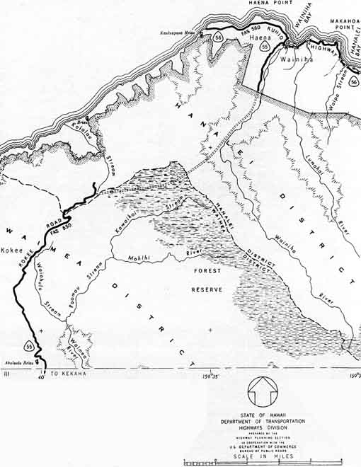
The three-quarter circle route around Kauai (consisting of part or all of state routes 50, 550, 56, and 560) is interrupted in the northwest by some very difficult terrain:
There were controversial efforts to build a road connection between Kokee Road, near the Kalalau Overlook in Kokee State Park, and Wainiha Powerhouse Road on the north shore. The approximate path of the proposed road is shown in the following excerpt from a 1962 state highway map:
(I hasten to add, however, that the presence of the proposed road on the map does not necessarily mean there were firm state plans to construct the road, or to build it on the routing shown on the map. Also, the numbering of the existing roads has since changed.)
Something like this road was considered by military planners in World War II, to facilitate troop movements to bases in west Kauai. Indeed, according to an old U.S. Navy Pacific Missile Range Facility press release, during the war the military built a temporary log road through the Alakai Swamp and down into the Wainiha Valley, for construction of a telephone line.
According to Robert Wenkam's "Kauai and the Park Country of Hawaii" (Sierra Club 1967), Kauai County began building the road in 1954, in hopes of opening northwest Kauai to commercial development. (That idea was controversial even in the Kauai business community, since local hotel and tour operators feared losing business if tourists could easily drive themselves around the entire island in a day without staying overnight.) However, construction was aborted after bulldozers clearing a path for the road got stuck in the Alakai Swamp, about four miles northeast from where they started on Kokee Road. At that point, engineers recommended that the project be discontinued due to its high costs and infeasibility, and requests for further funding were denied.
I saw some indications of an attempt to build a road northeast from Kalalau Overlook, over what is now the Pihea Trail, perhaps to try to thread the needle between the Kalalau Valley and the Alakai Swamp. Reportedly, that effort was abandoned when engineers decided further rock blasting along that route risked draining the unique high-altitude Alakai Swamp. (There is some confusion about whether the bulldozers that got stuck in the Alakai Swamp got there via the Pihea Trail -- which I doubt, it didn't look to me like any bulldozers made it that far down the trail -- or whether they followed a different path more closely resembling that outlined on the map above. I plan further research on this subject.)
Wenkam reported no futher attempts to resume the project thereafter, though when he wrote in 1967 he still worried that the project might be revived. However, annual reports by state highway officials from 1960 onward mention no progress on or plans to carry out the project, so by statehood the proposed road may have become little more than a dotted line on a map. By the early 1970s, even that line had disappeared from Hawaii DOT planning maps. As far as I know, the proposed road is and has long been officially dead. Strong environmental objections, and the limited need for a direct link between the lightly-populated northwest and southwest coasts, in addition to the engineering challenges posed by the difficult terrain, should keep it dead for the foreseeable future.
6.8 Are there any toll bridges or roads in Hawaii?
There was briefly, from August 2001 until April 2002, a county-operated toll road on the Big Island -- a temporary and mostly-unpaved 2.2 mile access road over a lava-covered part of the state route 130 right of way, to help tourists view lava flowing from the Kilauea volcano into the ocean. See page 2 of the Lava Closures road photos pages for more details on the access road, and the old access to the Royal Gardens subdivision that the toll road partially replaced. The county closed the toll road to the general public after the lava flows shifted several miles west into Hawaii Volcanoes National Park, well away from the road. However, the road was later reopened (to mile 1.9), and rough pavement added over the unpaved segments, after the lava flows shifted back within range of the road. Re-imposition of tolls has been considered (but so far rejected) by Hawaii County.
Some state legislators have proposed building, in partnership with private companies, a new toll tunnel on Oahu, from Ewa under Pearl Harbor to Sand Island near downtown Honolulu. This would provide Ewa residents a shortcut commuting route to downtown, potentially diverting traffic from the crowded Interstate H-1. While there is interest in the concept, no feasibility study has yet been conducted to flesh out and assess the proposal. More recently, Hawaii DOT has begun preliminary discussions on a proposed privately-funded toll road from Kapolei to downtown Honolulu, following Interstate H-1 (perhaps incorporating the existing HOV lanes and reversible "zipper lane") and the Nimitz Highway (part of state route 92).
6.9 How common are interchanges on Hawaii's non-freeway routes?
They are rare, though not nonexistent. Oahu and Maui each have a few, such as on several segments of the Farrington Highway in southwest Oahu, and on Main Street in Wailuku on Maui. There are none on Kauai, or on the Big Island. Traffic volumes usually do not require grade separation, except for the high-speed, high-volume freeways on Oahu.
Lanai and Molokai? They don't even have stoplights! (Cool! Let's see how long they can get by with just stop signs.)
6.10 Why are some place names, such as Kailua and Waimea, duplicated on different islands?
Until the late 18th century, Hawaii was divided into multiple kingdoms, which went their own ways on establishing place names (I guess the kings were too busy trying to do each other in, to bother with coordinating on place names). Place name duplication persisted long after unification of the islands. But what Kamehameha the Great left undone, the U.S. Postal Service ultimately accomplished, spurring name changes such as to the Big Island's Kailua (now Kailua-Kona) to avoid confusion with Kailua on Oahu, and to the Waimeas on Oahu and the Big Island to avoid confusion with Waimea on Kauai. (For postal purposes, the Waimeas on Oahu and the Big Island are now respectively Maunawai and Kamuela. But the Big Island's Waimea still often goes by the old name. And the smallest Waimea, on Oahu's north shore, remains the most famous due to its long-standing popularity with surfers, and also the short-lived TV series "North Shore" set largely in the fictitious Grand Waimea resort there.) Still a source of some confusion is Kilauea village on Kauai, which has nothing to do with the Kilauea volcano (postal address Volcano, not Kilauea) on the Big Island.
6.11 Is Kalawao County, on the north shore of Molokai, really a separate county?
Yes, really. Hawaii state law (Hawaii Revised Statutes section 326-34) states: "The county of Kalawao shall consist of that portion of the island of Molokai known as Kalaupapa, Kalawao, and Waikolu, and commonly known or designated as the Kalaupapa Settlement, and shall not be or form a portion of the county of Maui, but is constituted a county by itself." Moreover, the Maui County charter (section 1.2) disclaims jurisdiction over the three above-named villages that comprise Kalawao County. The county is definitely unusual -- the above state law goes on to say that most Hawaii laws regarding county government don't apply to Kalawao County, and that the county is to be administered by the state department of health, rather than by a locally-elected government like Hawaii's other four counties. But Kalawao is definitely a county of its own, and in particular it is not part of Maui County.
Kalawao County is coextensive with the Kalaupapa National Historical Park, and the Kalaupapa Settlement where the Hawaiian kingdom (and then the territory, and the state) used to exile those suffering from Hansen's disease (a/k/a "leprosy") beginning in the 1860s. The quarantine policy was lifted in 1969, after Hansen's disease became treatable on an outpatient basis and could be made non-contagious. However, many of the resident patients chose to remain, and the state has promised they can stay there for the rest of their lives. No new patients, or other permanent residents, are being admitted. The remaining patients are elderly (nobody under 70, as of March 2012), and their numbers are slowly declining (13, as of December 2011).
My guess is that Kalawao County was established as a separate county because the state and/or Maui County (which includes the rest of Molokai) wanted no Maui County involvement in or responsibility for the isolated Kalaupapa Settlement. I expect also that the county, and the unusual legal structure under which it operates, will live as long as the remaining patients, then it will be folded into Maui County. The state already is planning to turn the county over to the National Park Service when no patients remain there. The laws regarding state administration of the county would likely have to be changed as part of the transfer, and abolition of the county would be a logical part of those changes.
Kalawao County has some local roads, maintained by Hawaii DOT. But they are not connected to any others on Molokai, cut off from the rest of the island by sea cliffs more than a quarter-mile high (which, along with the rough shark-infested waters on the other three sides of the county, were the main reasons why it was chosen as a place of exile). Kalawao County can be reached only by small plane, by barge, or on foot or mule ride on a trail down the cliffs (I took the mule ride).
Kalawao County is unique in several ways:
-- Second smallest population of any county in the United States (barely exceeding -- for now -- only Loving County, Texas), with 90 residents in 2010, including nonpermanent health and park personnel, according to the Census Bureau.The county is, however, best known for its rich and inspiring history, first of the hellish conditions facing those exiled there, then the heroic efforts of the Belgian priest Damien de Vuerster (who ultimately contracted and died from Hansen's disease) and other Catholic priests and nuns to care for the exiles. Damien was formally declared a saint by Pope Benedict XVI on October 11, 2009. Pope Benedict, on October 21, 2012, also elevated to sainthood Mother Marianne Cope, who helped carry on St. Damien's work at Kalaupapa after his death. Many of the patients remaining in Kalawao County attended the canonization ceremonies in Rome for both St. Damien and St. Marianne.-- Smallest percentage of children of any U.S. county, with nobody at all under the age of 16 (state law generally forbids children from moving or even visiting there, though the state has made a limited exception for children visiting relatives residing in the county).
-- Smallest land area of any county in the United States (13.2 square miles).
-- The only county in the United States where entry without prior government permission is illegal. Visitors are permitted only as part of escorted tours (which will arrange the necessary permits, but do not allow any children under age 16, and do not operate on Sundays and some holidays), or as personal guests of county residents. The entry restrictions were originally to prevent the spread of Hansen's disease. They are no longer needed for that reason, but remain in place to protect the privacy and dignity of the Hansen's disease patients who have chosen to stay in Kalawao County.
For more on the history of the Kalaupapa Settlement and Kalawao County, see J.D. Bisignani, Maui Handbook (5th edition 1999, Moon Publications), pp. 375-378 (this is what led me to add Kalawao County to my autumn 1999 vacation itinerary). Also check out my Kalawao County photos page, which includes not only some photos by me and other contributors (including a few of the threatening warning signs at the mule trail and airport entrances to the county), but also links to additional photos and other informative sites.
6.12 What street address numbering systems are used in the islands?
Lanai, Maui, and Molokai, and parts of the other islands (mainly urban areas and military bases) have conventional numbering systems. However, the rural numbering systems on Oahu, the Big Island, and Kauai are unusual. The following discusses in detail the Oahu system. The Big Island's system (except the signage) is quite similar, and Kauai's is also somewhat similar (the main difference is that its hyphenated address numbers have only one digit before the hyphen, indicating which of the island's five tax districts the property is located in).
Oahu is divided into 9 districts/tax zones, each subdivided into nine sections. In most cases, if you're not in a main town or on a military base, the tax zone and section you're in determines the address numbers that you'll see. Here's what a rural Oahu street sign looks like:
The first two digits on the sign, before the hyphen, give you the tax zone: 5-Koolauloa and its section 4-Haaula and Kaipapau. The three (sometimes four) digits after the hyphen are the address numbers. In Zones 4-6, 8, and parts of 9, this system can be used to find your location on the island with a fair degree of accuracy, if you have a map that indicates these zones (such as Bryan's Sectional Maps of Oahu). Honolulu County is pretty consistent in posting these signs on the main roads.
Occasionally, you'll see a sign that looks like this:
This sign indicates a tax zone boundary; expect the address numbers to change.
The districts/tax zones are:
1-3: HONOLULU (separate address number system)The address prefix before the hyphen is always two digits. The suffix is three or four digits, starting at 100 (or sometimes 0) where the street begins within the tax zone, and increasing consecutively. This system can yield some very high address numbers, with the highest I could find on Oahu being 99-1849 Aiea Heights Drive, in the consonant-challenged Honolulu suburb of Aiea. (The Big Island also has 99-xxx address numbers around its southern tip, but there aren't enough houses or other lots on any road within that section to drive the address suffixes into four digits.)
4: KOOLAUPOKO (Kaneohe)
5: KOOLAULOA (NE North Shore)
6: WAIALUA (NW North Shore)
7: WAHAIWA (Central Oahu -- separate address number system)
8: WAIANAE (West Oahu-Makaha/Kaena Point)
9: EWA (West Loch of Pearl Harbor, Waipahu, Ewa Beach, Aiea)
Honolulu's independent numbering system is reasonably easy, and well posted, too. There are three sequences:
1. For roads running parallel to the ocean:1a. NORTHWEST ("ewa") of Nuuanu Avenue, numbers increase in a northwesterly direction. Odd address numbers are on the makai (ocean) side of the street, even on the mauka (inland) side of the street. The names of main streets begin with North.2. For roads running more or less at right angles to the ocean (i.e., southwest to northeast): Address numbers increase as you head mauka (inland), and even numbers are on the left facing mauka.1b. SOUTHEAST ("diamondhead" or "kokohead") of Nuuanu Avenue, numbers increase in a southeasterly direction. Address numbers are placed as above. The names of main streets begin with South.
6.13 Where in Hawaii can I find "Gilligan's Island"?
The island shown in the opening credits of that TV show during its second and third seasons reportedly was Coconut (Mokuoloe) Island, in the middle of Kaneohe Bay on the east coast of Oahu. The shot used for the show was most likely shot from somewhere along the bay's south shore, near Kaneohe Bay Drive, though the exact location may be on private property. Nowadays, a research station occupies the island and is visible from the south shore, so it's too late to replicate the image used on the show.
Coconut Island is less than half a mile from residences lining the shore of Kaneohe Bay, and downtown Kaneohe is just a little more distant. If the S.S. Minnow actually had been stranded there, everybody would've been rescued by the end of the first episode. That would've been no fun!
This is the end of the FAQs.
 to Page 1: Table of contents,
"About this site" |
 to Page 5: Bridges, tunnels,
and ferries |
Links to main page and other parts of Hawaii Highways site, and related sites:
Comments, more questions, etc.? Please e-mail me.
© Oscar Voss. Last updated February 2015.