| Hawaii Highways road
photos -- Interstate H-1 (page 1 of 2)
(Oahu part 2 of 6 -- other Oahu
parts: Interstate H-3 ·
Other
Freeways
Other
Oahu South · Other
Oahu West · Other
Oahu East)
This part has 30 photos of Hawaii's Interstate H-1
(Queen Liliuokalani Freeway west of exit 19, including the viaduct passing
north of Honolulu International Airport; Lunalilo Freeway to the east).
H-1 is Hawaii's oldest freeway, with some segments built before Hawaii
became a state in 1959 (believe me, it shows), though the entire route
was not completed until the late 1980s.
Most of the photos are my own. Page 2 includes one historic road photo from the archives of the Federal Highway Administration's predecessor, the U.S. Department of Commerce's Bureau of Public Roads.
Because of the large number of photos, this part is
divided into two pages. The photos below cover the Queen Liliuokalani Freeway
(exits 1-18). Page 2,
which follows, covers the Lunalilo Freeway (exits 19-27), and also provides
links to a related site and to the rest of the Hawaii Highways road photos
collection.
NOTE: In case you want more detail, you can click many of
the photos below (for now, mainly some of the 2001 photos) to view an enlarged,
higher-quality (less .jpg compression) version. Those alternate versions
have larger file sizes, so please be patient while they download.
 |
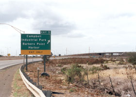 |
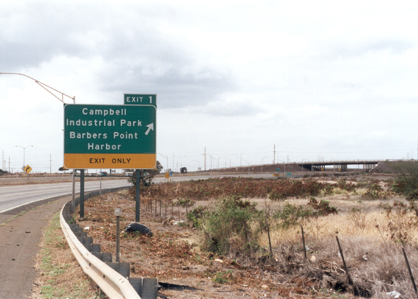
 The west end of Interstate
H-1, viewed from the west, where the Farrington Highway (state route 93)
turns into H-1, at an unsigned point between the beginning of the concrete
median barrier and the overpass in the background. (September 1999) The west end of Interstate
H-1, viewed from the west, where the Farrington Highway (state route 93)
turns into H-1, at an unsigned point between the beginning of the concrete
median barrier and the overpass in the background. (September 1999)
|
From the east,
the west end of Interstate H-1 is about 300 feet west (on the other side)
of the overpass in the background on the right, which takes Kalaeloa Boulevard
(unsigned state route 95) over the freeway. (November 2001) |
 The crossed zero pavement
marking on the westbound shoulder, and a similar marking painted on the
median barrier, are the only indications of H-1's exact west end. While
the highway changes at this point from an Interstate to a state route (Farrington Highway, state route 93), it remains a freeway for a little more than a mile, until its at-grade intersection with Laaloa Street. (November 2001) The crossed zero pavement
marking on the westbound shoulder, and a similar marking painted on the
median barrier, are the only indications of H-1's exact west end. While
the highway changes at this point from an Interstate to a state route (Farrington Highway, state route 93), it remains a freeway for a little more than a mile, until its at-grade intersection with Laaloa Street. (November 2001) |
|
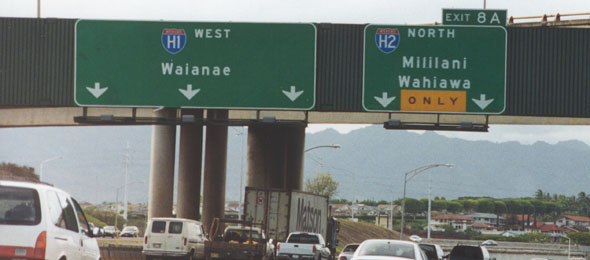 |
The junction
with H-2, from the westbound lanes. (October 1999)
|
 |
A broader
telephoto view of the same junction, from the Leeward Community College
access overpass to the east, showing H-1's "zipper lane" (eastbound, morning
rush only -- this photo was taken just after the zipper lane was closed
at 8am), and the ramp onto the zipper lane from southbound Interstate H-2.
(May 2000)
|
 |
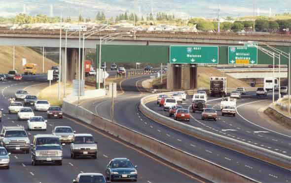
HOV-3 express
"zipper lane", HOV-2 carpool lane, shoulder lane ... Hawaii DOT pulls out
all the stops to accommodate rush-hour traffic without widening this stretch
of eastbound H-1, just east of the junction with H-2. Just don't break
down here during the morning rush, please! (May 2000)
|
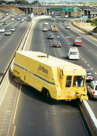
The "Zipmobile"
in action at the end of the morning rush on H-1, moving eastbound (toward
me) to convert the single zipper lane back into two westbound lanes. (Note
the "guide line" for the Zipmobile operator, in the middle of the westbound
#2 lane.) Hawaii DOT is considering whether to implement a similar zipper
lane arrangement for the afternoon rush, to convert two eastbound lanes
into one HOV-3 westbound lane. However, a left exit to and entrance from
Interstate H-2 would make a westbound zipper lane more complicated than
the eastbound lane. (May 2000)
|
|
 |
 |
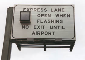
Overhead sign
at one of the four entrances from eastbound H-1 to the zipper lane. As
the sign notes, there is only one exit from the zipper lane, just west
of the airport where it turns into an HOV-3 morning rush-only shoulder
lane. (October 1999)
|
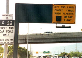
West of the
airport, near the east end of the zipper lane, a warning to westbound traffic
when it will lose the two left lanes, to make room for the eastbound zipper
lane. (October 1999) |
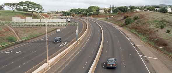 |
Yet another
view of H-1's zipper lane, facing westbound from the Moanalua Freeway (state route 78/Interstate H-201) overpass. (November 2001)
|
|
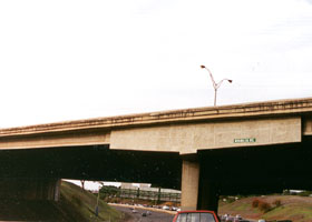
 One of two
unusually-configured "hammerhead piers" on overpasses over Interstate H-1
northeast of Pearl Harbor. This overpass is for Moanalua Road, now the
Moanalua Freeway (state route 78/Interstate H-201). (October 1999) One of two
unusually-configured "hammerhead piers" on overpasses over Interstate H-1
northeast of Pearl Harbor. This overpass is for Moanalua Road, now the
Moanalua Freeway (state route 78/Interstate H-201). (October 1999) |
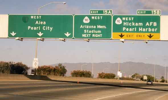 |
These overhead
signs on westbound H-1 direct traffic through the complex interchange at
the west end of the Airport Viaduct. The middle sign, as well as a similar
sign on state route 92 under the viaduct, still refer to the Kamehameha
Highway east of Pearl Harbor as route 90, long after it was renumbered
to state route 99. This is perhaps the most prominent highway "sign goof"
in the islands, though it doesn't seem to be terribly confusing to anybody
-- overhead signs both before and after this one show the correct route
number, the middle sign correctly indicates the tourist destinations reached
via "route 90," and local residents don't pay much attention to route numbers
anyway. (November 2001)
|
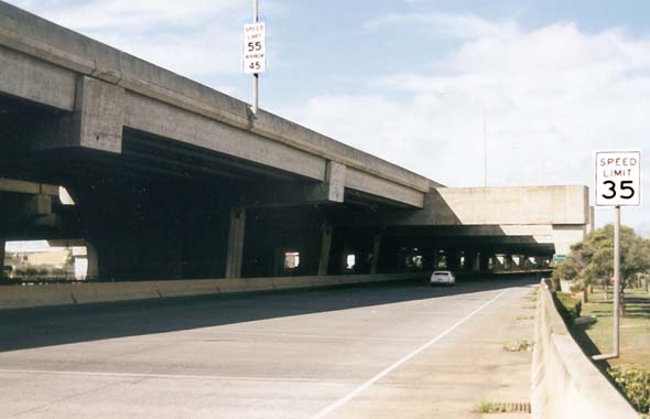 |
Facing westbound,
part of the Airport Viaduct carrying H-1 over the Nimitz Highway (state
route 92), just west of exit 18. The viaduct is almost three miles long
(Hawaii's longest bridge). The Nimitz Highway continues under the viaduct
for the rest of its length, until it emerges from underneath and continues
west while H-1 curves northwest. (November 2001 - contrast enhanced on
speed limit signs)
|
 |
| East of the
airport, as H-1 enters a 35 mph half-mile S-curve between the Nimitz Highway
(state route 92) and the Moanaloa Freeway, is this overhead sign with a faded old-style H-1 route shield with a hyphenated route number. While the route number officially includes a hyphen, the newer route shields posted on freeways omit the hyphen. (September 1999) |

Page 2: Lunalilo Freeway (H-1 east of exit 18)
|
|
or directly to other parts of the Hawaii Highways road photos collection:
Overview ·
Introduction · Interstate H-3 ·
Other Freeways · Other Oahu South
Other Oahu West ·
Other Oahu East ·
Kuhio
Highway ·
Other Kauai ·
Hana
Highway
Piilani Highway
·
Kahekili Highway ·
Other Maui · Lanai/Molokai
Kalawao County ·
Saddle Road ·
Observatories Roads ·
Lava Closures
Red Road ·
Waipio Valley ·
Other Big Island
or to other sections of the Hawaii
Highways site:
Comments, etc.? Please e-mail me.
© 1999-2004, 2006 Oscar Voss.
|