| Hawaii
Highways Road Photos -- Hana Highway (page 1 of 2)
(Maui part 1 of 4 -- other Maui
parts:
Piilani
Highway · Kahekili Highway ·
Other
Maui)
The 30 photos in this part, from my October 1999, May 2000, and November
2001 visits to Maui (plus two historic road photos), are from the most scenic stretch of the famous Hana Highway, Hawaii state highway 360 from central Maui along the northeast
coast to Hana, part of state route 36 through Paia, and the east end of
county highway 31 from mile 51.8 to Oheo Gulch and Kipahulu (after which
it becomes the Piilani Highway at mile 38.5, with a separate
photo collection following this one). Following the photos are links
and other references to some of the many books and other sites about the
highway.
The Hana Highway was designated in 1999 as a National Millenium Legacy Trail, and in June
2001 most of it was added to the National Register of Historic Places.
But it has long been known as one of the nation's most scenic highways,
and one of Maui's major tourist attractions. It is also a notoriously narrow,
winding road, with hundreds of hairpin curves, dozens of one-lane historic
bridges, and typical average speeds of only 15 mph (allow at least
three hours from Kahului to Oheo Gulch, preferably more to make time for
the abundant photo opportunities along the way). Many tourists hate to
drive the road at night, though I and many east Maui residents prefer
night driving (less sightseer traffic, and on blind curves you get more
advance warning of oncoming traffic from their headlights) -- but do try
to cover the road in at least one direction in daylight, on a good day
when you're not in a hurry, with a camera and lots of extra film.
Also, there is only one gas station in all of east Maui, in Hana,
with just one pump (which once stranded me in Hana for several hours when
it broke down), and prices about 25¢ per gallon higher than in central
Maui. So make sure to fill up in Kahului or Paia before heading out to
Hana.
This road is the subject of many books and web sites, some of which
are listed at the bottom of page 2,
and including some with excellent photos of the road and the scenery along
the way and/or historical information.
This part of the road photos collection is divided into two pages. Below
is introductory information about the entire highway, plus photos
of or from the highway from Paia near its western end, east to the end
of state route 360 in Hana.
Page 2 completes the journey, with photos from county route 31 from Hana to Kipahulu, where the Hana Highway meets the Piilani Highway (remainer of county route 31), as well as links to the rest
of the road photos collection, other sections of the Hawaii Highways site,
and other relevant sites.
Note: In case you want more detail, clicking some of the photos
below (for now, mainly the ones from my 2001 trip, plus some from 2000) will
call up enlarged, higher-quality (less .jpg compression) versions. Those
alternate versions have larger file sizes, so please be patient while they
download.
Map of Maui, with Hana and Piilani Highways
highlighted:
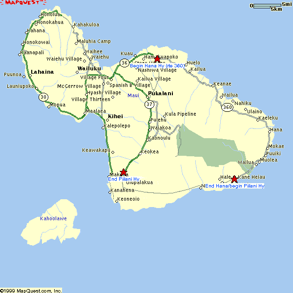

|
 |
 |
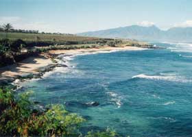
 East of Paia
off route 36 at mile 8.9, the parking lot for Hookipa Beach (a favorite
windsurfing spot) offers a view of the beach to the west, and the west
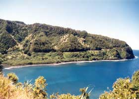
Maui mountains beyond. (November 2001) East of Paia
off route 36 at mile 8.9, the parking lot for Hookipa Beach (a favorite
windsurfing spot) offers a view of the beach to the west, and the west
Maui mountains beyond. (November 2001) |
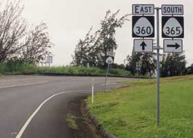
Here is where
the Hana Highway starts getting really interesting, as it changes
from primary state route 36 to secondary state route 360, at the junction
with Kaupakalua Road (county route 365 -- like most marked county highways
in Hawaii, the route shield is the same as for state routes). The "end"
marker for route 36 in the background is unusual for Maui. (November 2001)
|
 |
 |
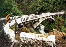
One of the
many historic one-lane bridges on the state route 360, and county route
31, segments of the Hana Highway, protected by the overall state and Federal
historic designation for most of the highway (something which complicates
needed maintenance and renovation of many of those bridges). Most date
back to the 1910s and 1920s, when the road was just a horse
and wagon trail (it was later turned into an auto road). (May 2000)
|
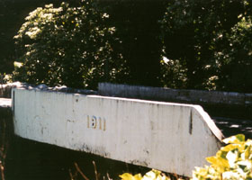
The Kolea Bridge at mile 13.2, like
many other one-lane bridges on the Hana Highway built in the early 1910s,
has the construction date marked on the side. (May 2000) |
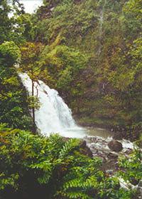
 One of the
many drive-up waterfalls along the Hana Highway (Waikani Falls, at mile 19.5). The waterfalls are especially beautiful
just after it's rained, which is often along the northern and eastern coasts
of Maui, as the Haleakala volcano wrings moisture from the trade winds. (May 2000) One of the
many drive-up waterfalls along the Hana Highway (Waikani Falls, at mile 19.5). The waterfalls are especially beautiful
just after it's rained, which is often along the northern and eastern coasts
of Maui, as the Haleakala volcano wrings moisture from the trade winds. (May 2000) |
|
 |
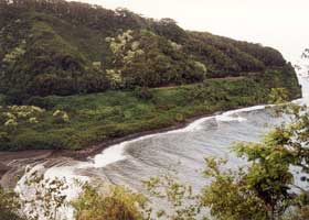 |
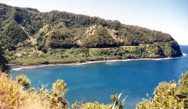
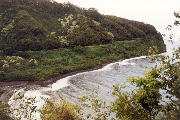
Two views
of a winding stretch of the Hana Highway east of mile 13 (photographed
from around mile 14), cut into the side of a cliff on the west side of
Honomanu Bay. Here and elsewhere, the highway offers spectacular
ocean views for passengers (drivers are too busy keeping their cars on
the road, and avoiding oncoming traffic rounding the narrow blind curves).
(October 1999 and November 2001, respectively)
|
|
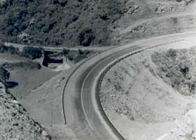
 This photo of a realignment project (perhaps Kakipi Gulch, or some other point west of mile 3 near Huelo, where a new Hana Highway alignment was completed in the early 1960s), shows one of the few efforts to straighten out curves on the Hana Highway. (1965, Bureau of Public Roads, U.S. Department of Commerce; located in archived BPR records, project file S-360(3), accession number 30-70-A-221, records group 30; courtesy of the National Archives and Records Administration - Pacific Region, San Francisco) This photo of a realignment project (perhaps Kakipi Gulch, or some other point west of mile 3 near Huelo, where a new Hana Highway alignment was completed in the early 1960s), shows one of the few efforts to straighten out curves on the Hana Highway. (1965, Bureau of Public Roads, U.S. Department of Commerce; located in archived BPR records, project file S-360(3), accession number 30-70-A-221, records group 30; courtesy of the National Archives and Records Administration - Pacific Region, San Francisco)
|
 |
 |
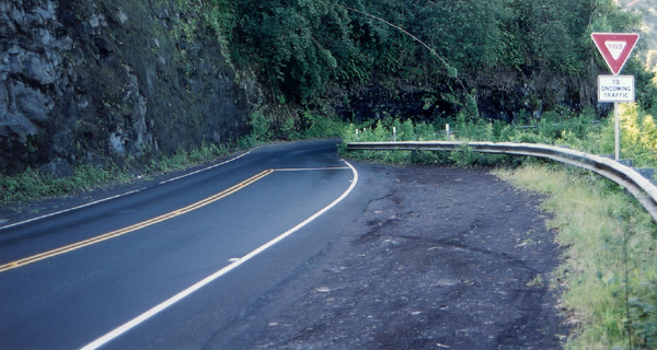
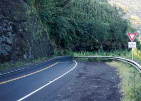
At mile 14.3 (facing westbound), the highway briefly narrows
to one lane. Similar bottlenecks, in addition to dozens of one-lane bridges,
make for a slow trip to Hana. (November 2001)
|
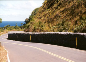
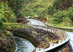
A gabbion
basket barrier on a landslide-prone section of the Hana Highway, at mile
16.1. (October 1999) |
 |
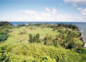 |
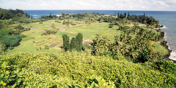
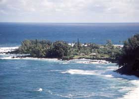
Two views
of the Keanae Peninsula, from the highway west of the peninsula at mile
16.1 (above left), and inland at mile 17.1 (above right). (Both photos
November 2001)
|
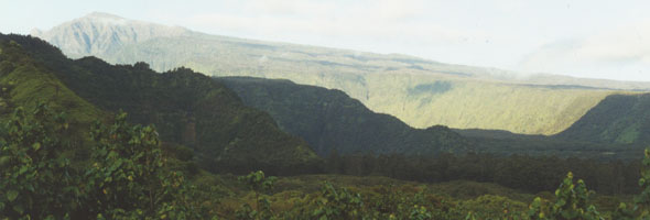 |
The Ko'olau
Gap eroded into the north side of the Haleakala volcano crater, viewed
from the Wailua Valley Lookout just off the highway at about mile 18.9.
(May 2000)
|
 |
 |
This stretch
west of Hana, at mile 22.1 east of Pua'a Ka'a State Park, winds along a
canal built by the East Maui Irrigation Company. It's posted for 15 mph.
This is the highest stretch of the Hana Highway, reaching elevations of
around 1200 feet. (May 2000)
|
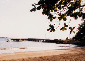
Route 360
technically ends here, at the Hana Bay wharf at the end of Keawe Place
in Hana. However, the Hana Highway continues past Hana, as county route
31 (see page 2). (May 2000) |
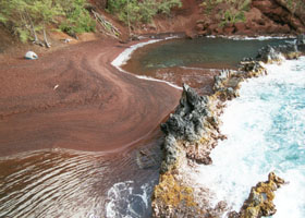 |
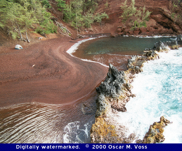
On the other
side of Kauiki Head from the Hana Bay terminus of route 360 is the spectacular
Kaihalulu (Red Sand) Beach. It is in a collapsed volcanic cinder cone,
so much of the "sand" is rough cinder (ouch!). The natural breakwater makes
the water much calmer inside the cove than outside (beware the rip current
at the north end of the breakwater). That, plus the beach's seclusion,
and treacherous loose cinder trail access (from the Hana Community Center,
about ¼ mile from Hana Bay) holding down the crowds, make it popular
with nude snorkelers. (May 2000) |

Page 2: Hana-Kipahulu, and links
|
or directly to other parts of the Hawaii Highways road photos collection:
Overview · Introduction · Interstate H-3 ·
Interstate H-1 · Other
Freeways
Other Oahu South · Other Oahu West · Other Oahu East ·
Kuhio Highway
Other Kauai · Piilani Highway · Kahekili Highway
· Other Maui · Lanai/Molokai
Kalawao County · Saddle Road · Observatories
Roads · Lava Closures
Red Road · Waipio Valley · Other Big Island
or to other sections of the Hawaii Highways site:
Comments, etc.? Please e-mail me.
© 1999-2006 Oscar Voss (no copyright claimed on National Archives photo,
which is in the public domain). |