| Hawaii
Highways road photos -- Red Road
(Big Island part 4 of 6 -- other
Big Island parts: Saddle Road ·
Observatories
Roads · Lava Closures
· Waipio Valley ·
Other Big Island)
The following 13 photos cover the Kapoho-Kalapana Road
(county route 137) along the Big Island's southeastern coast northeast
of Hawaii Volcanoes National Park. The road has long been known as the
"Red Road" because of its unusual red cinder pavement. Most of the original
red pavement has been resurfaced with black asphalt in 2000 or, at its
southern end, black lava from the 1990 flows that destroyed Kalapana village.
Local residents protested the black asphalt resurfacing, but the road badly
needed a new smoother surface, the red pavement could not be replaced in
its original form (which used bunker oil, now an environmental no-no),
and the county rejected alternate red pavements as too costly. The residents
did not take the county up on its offer to supply red paint for volunteers
to spray on the new pavement.
The photos below include some with the original pavement,
along with current photos of this still-pleasant oceanside country road.
All the photos below are my own, except one historic
road photo from the archives of the Federal Highway Administration.
NOTE: In case you want more detail, clicking most of the photos
below will call up enlarged, higher-quality (less .jpg compression) versions.
Those alternate versions have larger file sizes, so please be patient while
they download.
 |
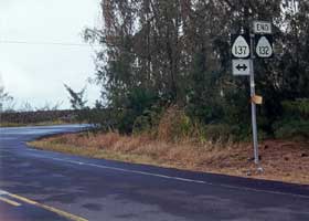 |
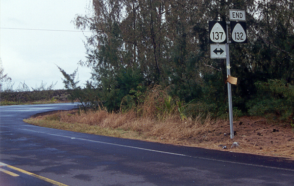
 Two views
of the north end of the Red Road, at county route 137 mile 7.7 where it
intersects with Pahoa-Kapoho Road (county route 132 west of the intersection).
Above left is the intersection facing south, with the Red Road straight
ahead. Above right is the intersection from the west, with an "end" sign
announcing the end of route 132 (unusual for Hawaii). Pavement continues
briefly north of the intersection, until the road (at this point, not normally
considered part of the Red Road, and despite the milemarkings and the junction
sign above right, not necessarily part of county route 137) turns unpaved
and then turns northwest to follow the coast. (Photo above left November
2001; photo above right May 2000) Two views
of the north end of the Red Road, at county route 137 mile 7.7 where it
intersects with Pahoa-Kapoho Road (county route 132 west of the intersection).
Above left is the intersection facing south, with the Red Road straight
ahead. Above right is the intersection from the west, with an "end" sign
announcing the end of route 132 (unusual for Hawaii). Pavement continues
briefly north of the intersection, until the road (at this point, not normally
considered part of the Red Road, and despite the milemarkings and the junction
sign above right, not necessarily part of county route 137) turns unpaved
and then turns northwest to follow the coast. (Photo above left November
2001; photo above right May 2000)
|
 Pahoa-Kapoho
Road continues as an unpaved road past the Red Road junction, to the Cape
Kumukahi lighthouse. The lighthouse escaped the 1960 lava flows that destroyed
Kapoho village, then split around the lighthouse before rejoining and entering
the sea. Legend has it that the evening before the eruption began, volcano
goddess Pele posed as an old woman begging for food. She got no help from
the villagers, but got a meal from the lighthouse keeper. (May 2000) Pahoa-Kapoho
Road continues as an unpaved road past the Red Road junction, to the Cape
Kumukahi lighthouse. The lighthouse escaped the 1960 lava flows that destroyed
Kapoho village, then split around the lighthouse before rejoining and entering
the sea. Legend has it that the evening before the eruption began, volcano
goddess Pele posed as an old woman begging for food. She got no help from
the villagers, but got a meal from the lighthouse keeper. (May 2000) |
|

|
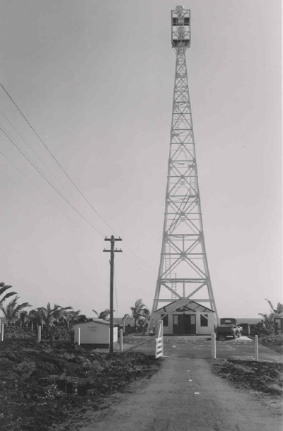
 This historic
photo shows the narrow but paved road that had provided access to the Cape
Kumukahi lighthouse, until the road was largely covered by the 1960 lava
flows that almost also destroyed the lighthouse. (1955, Bureau of
Public Roads, U.S. Department of Commerce; located in archived records
of the Federal Highway Administration, route report file for Hawaii FAS
132, accession number 74-1561, records group 406; courtesy of the National
Archives and Records Administration - Pacific Region, San Francisco) This historic
photo shows the narrow but paved road that had provided access to the Cape
Kumukahi lighthouse, until the road was largely covered by the 1960 lava
flows that almost also destroyed the lighthouse. (1955, Bureau of
Public Roads, U.S. Department of Commerce; located in archived records
of the Federal Highway Administration, route report file for Hawaii FAS
132, accession number 74-1561, records group 406; courtesy of the National
Archives and Records Administration - Pacific Region, San Francisco)
|
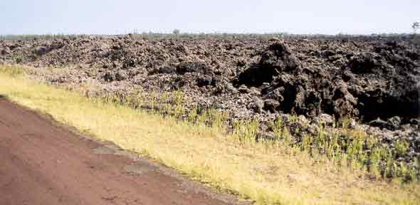 |
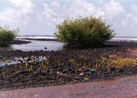
The original
red pavement begins at mile 8.1, just south of the junction with county
route 132. Here, a mile to the south, are some of the lava fields on both
sides of the Red Road as it approaches its north end, full of rough and
jagged a'a lava (named for the sound you'll make if you scrape yourself
on it -- compare to lava's other flavor, smooth pahoehoe),
perhaps from the 1960 eruption that destroyed Kapoho village and bypassed
the Cape Kumukahi lighthouse. (Novermber 2001)
|
 |
 |
|
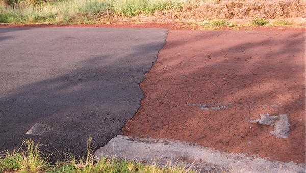
Three
views of the transition, at mile 10.1, from the original red cinder pavement
to the new black asphalt surface applied in late 2000. The photo above
left was taken right at the transition point; above right, from the north;
and left, from the south. (All three photos November 2001) |
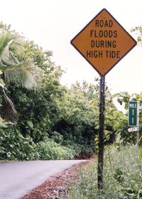
At one very low-lying
point just south of mile 11, the Red Road sometimes is underwater at high
tide. The road was originally built on high ground, then the ground --
along with the rest of the Puna coast -- suddenly sank a few feet in 1975.
This portion of the Red Road was repaved in 2000, but like most of the
road remained only 16 feet wide. (November 2001) |
|
 |
This is
the stretch of the Red Road, just north of Isaac Hale Beach Park, that
sometimes floods at high tide. This photo was taken near high tide, where
the tide was not quite high enough to reach the road, but as you can see
it comes pretty close (less than a foot lower than the road surface), and
before the red pavement was covered with black asphalt. A developer's controversial
plans for a new resort in this area include rerouting this part of the
Red Road, inland and on higher ground. (May 2000)
|
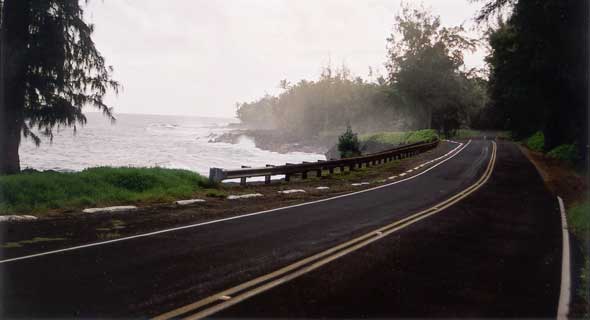 |
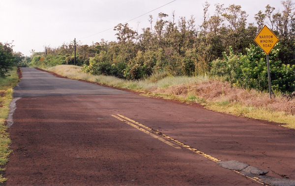
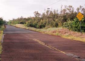
At mile 14.6,
one of the more scenic oceanside stretches of the Red Road is also its
widest and most improved after the repaving, with two full lanes of pavement
(rather than the usual two unmarked 8-foot-wide lanes), reflectorized lane
markings, and a guardrail. (November 2001)
|
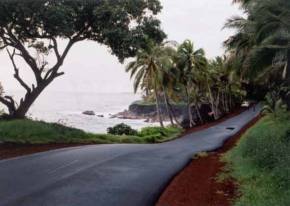 |
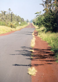
An even more scenic part of the Red Road near mile 17. (November 2001)
|
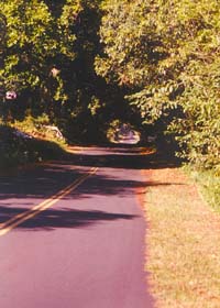
A "tree tunnel" near
mile 18 of the Red Road surrounds the entrance off to the left for the
Kalani Honua resort where I stayed on my 2000 and 2001 visits to the
Big Island. This photo shows a relatively smooth segment of the old Red
Road pavement. (October 1999) |
|
|
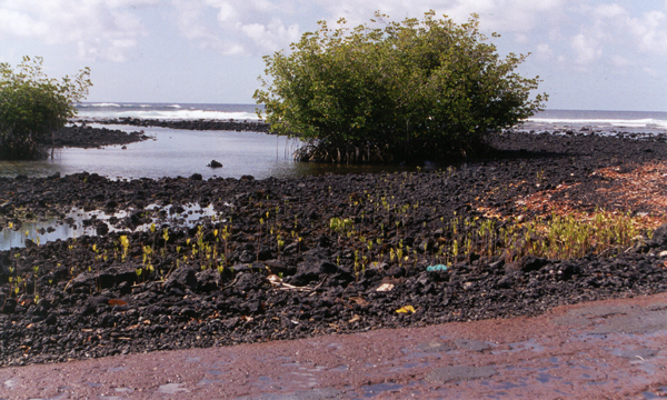
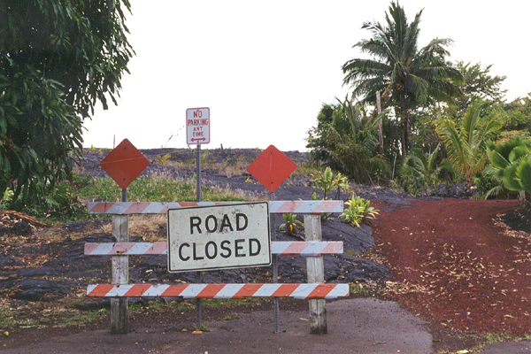
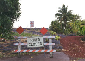
The Red Road is cut
short here in Kaimu at mile 22.3, about three miles north of its original
terminus in Kalapana village, by the lava flow that destroyed Kalapana
in 1990. During the day, there usually is a fruit stand parked here. (October 1999) |
On my hot springs site, see my photos
of two hot springs near Isaac Hale Beach Park along the Red Road, plus
a related page with photos
of Kehana Beach at around mile 19 near the road's south end.
See also Mark
Furqueron's Hawaii road photos page for one of his Red Road photos.
Go to the previous or next parts of the Hawaii Highways road photos
collection:
or directly to other parts:
Overview ·
Introduction
· Interstate H-3 ·
Interstate
H-1 · Other Freeways
Other Oahu South ·
Other
Oahu West · Other Oahu East ·
Kuhio
Highway
Other Kauai ·
Hana
Highway · Piilani Highway
· Kahekili Highway ·
Other
Maui
Lanai/Molokai
· Kalawao County ·
Saddle
Road · Observatories
Roads
Other Big Island
or to other sections of the Hawaii Highways site:
Comments, etc.? Please e-mail me.
© 1999-2003, 2005, 2007 Oscar Voss (no copyright claimed on National Archives photo, which is in the public domain). |