Hawaii Highways Road Photos --
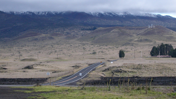
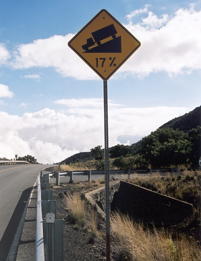
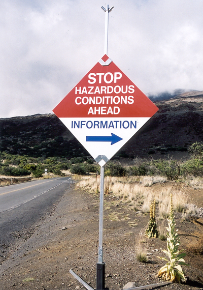
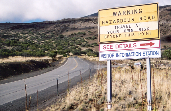
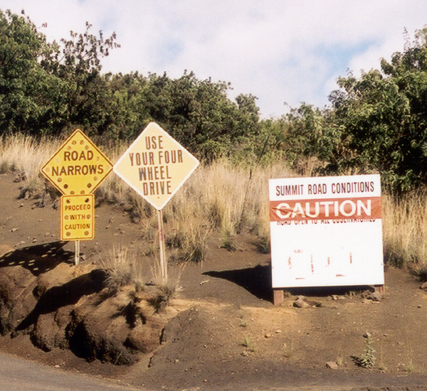
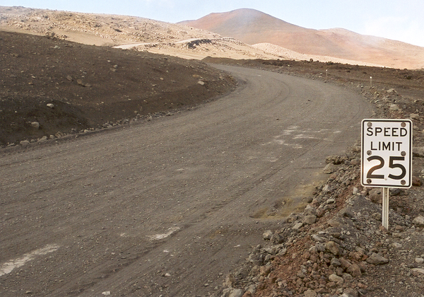
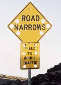
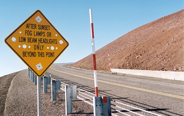
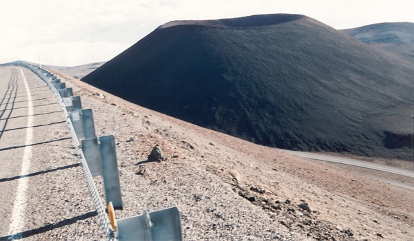
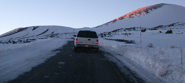
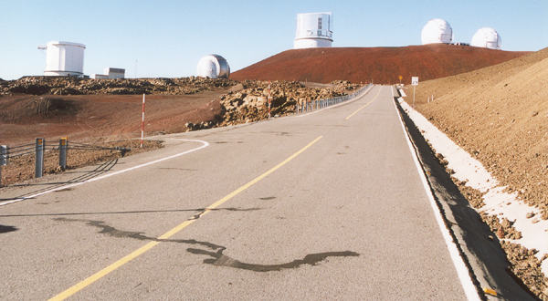
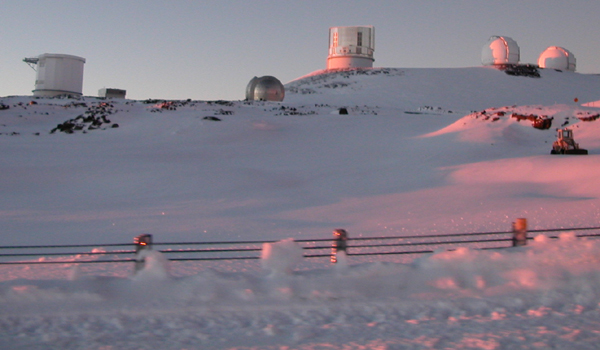
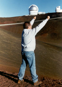
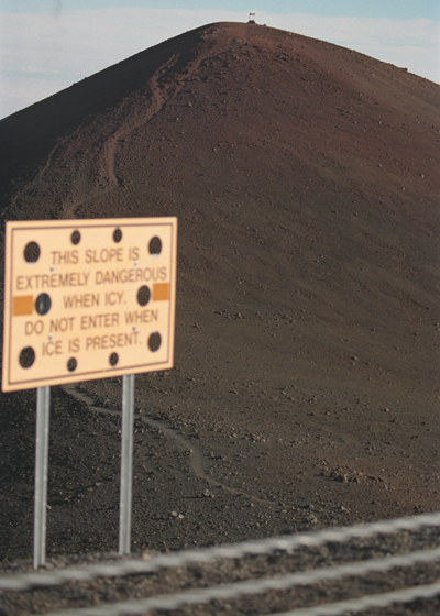
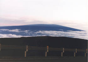
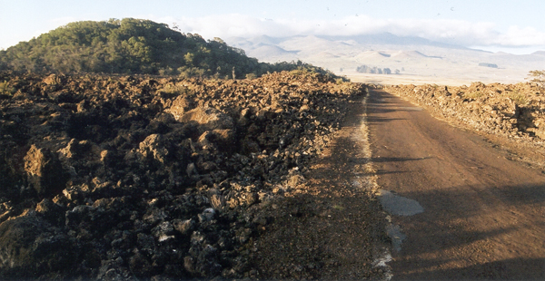
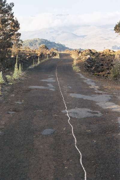
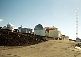
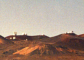
Mauna Kea and Mauna Loa Observatories Roads

(Big Island part 2 of 6 -- other Big Island parts: Saddle Road ·
Lava Closures · Red Road · Waipio Valley · Other Big Island)

Here are 22 photos of the ultra-high-altitude side roads branching from Saddle Road across Hawaii's Big Island, to the observatories atop Mauna Kea and on the north slope of Mauna Loa, Hawaii's two highest mountains. All the photos are my own, from my visits in October 1999 and November 2001, except four photos taken by Tim Reichard on his January 2005 visit to the Big Island.

The road to the Mauna Kea summit, named John A. Burns Way (though more often just called "the Mauna Kea summit road"), is about 15 miles long. It branches north from Saddle Road, near mile 28. It is paved for the first six miles, to the Visitor Information Station of the Onizuka Center for International Astronomy, at about the 9300' level. Beyond there, the road becomes steep and unpaved for about five miles. The remaining four miles approaching the summit are paved, and not as steep. Just before the end, the road reaches its highest elevation at 13780', making it the third highest auto road in the United States, as well as the highest in Hawaii. From that point a short hike will take you to the Pu'u Wekiu summit at 13796', the highest point in Hawaii. The Mauna Kea summit area is extremely popular with astronomers worldwide, mainly for its clear and thin air, and minimal light pollution.

The road to the weather observatory on the north slope of the Mauna Loa volcano is 17.1 miles long, branching south from Saddle Road 0.1 mile east of the turnoff for the Mauna Kea summit road. It is the second-highest road in Hawaii, a paved one-lane road with narrow shoulders passing through bleak lava fields. The weather observatory is operated by the National Oceanic and Atmospheric Administration, and conducts long-term monitoring of changes in the upper atmosphere. Also at road's end is one of the trailheads for a long and strenuous hike to the Mauna Loa summit. The U.S. Department of Transportation plans to resurface and otherwise improve the road, beginning in mid-2005.

NOTE: In case you want more detail, clicking some of the photos below (for now, just some from my 2001 trip, and Tim Reichard's 2005 trip photos) will call up enlarged, higher-quality (less .jpg compression) versions. Those alternate versions have larger file sizes, so please be patient while they download.


Warnings: Parts of Saddle Road, which you must travel to get to either of the observatories roads, are very narrow, with rough pavement edges, making head-on collisions a real problem. Dense fog, as moist air rising upslope from the coast meets cold air flowing downslope from Mauna Kea and Mauna Loa, can make for dangerously low visibility. The road west of the "saddle" is also not well reflectorized for night driving.

Most rental car companies prohibit taking their vehicles on Saddle Road, or the observatories roads branching off from it (Harper's, in Hilo and Kailua-Kona, is a notable exception). Also, there are no travel services at all on Saddle Road or on the observatories roads. Make sure to refuel in Hilo before heading west, or Waimea, Waikoloa, or Kailua-Kona before heading east -- the high altitude can increase your fuel consumption quite a bit.

The roads to the Mauna Kea and Mauna Loa observatories both take you above 11000'. The Mauna Loa road is paved but narrow, through jagged lava that can tear up your tires if you stray from the pavement -- which can be a task in poor visibility, since the road has little or no reflectorization, other than a thin fog line in the center of the pavement (see below -- all this may change, after the improvements planned to begin in mid-2005). The Mauna Kea road includes a steep (15% grade) unpaved stretch that, beyond the visitor center at about 9300', is restricted to 4-wheel-drive vehicles, and also has other restrictions to protect visitors and astronomers' work at the summit's many observatories (including a recommendation to hang around the visitor center at least a half-hour, for people ascending from sea level to acclimate and reduce the risk of altitude sickness at the summit). The Mauna Kea road is sometimes closed by snow in the winter, and the Mauna Loa road occasionally gets snowbound as well.

The Mauna Loa volcano is active, though not currently erupting. An eruption could close the Mauna Loa observatory road, or the Saddle Road access to the Mauna Kea summit road, though such closures are improbable (the most recent eruption, in 1984, did not close the Mauna Loa observatory, the road up to the observatory, or Saddle Road), and there will be plenty of advance warning in any case. The Mauna Loa volcano is closely watched by the Hawaii Volcano Observatory, whose web site will have current information on any signs of trouble.


Mauna Kea summit road (John A. Burns Way)
 
John A. Burns Way approaching cloud-enshrouded Mauna Kea, with two smooth lanes of pavement and a 40mph speed limit
 

The road to the Mauna Kea summit begins here at its junction with Saddle Road, gradually ascending toward the (at that point) cloud-enshrouded Mauna Kea, with two smooth lanes of pavement and a 40mph speed limit. (January 2005, courtesy of Tim Reichard)
 

The road south of the visitor center is in good shape, but just south of the center is a short 17% grade, to offer a preview of the steep grades beyond the center. This photo shows the road southbound, about to go downhill. (November 2001)
17% downgrade sign near the visitor center, facing southbound
 
View from above of the visitor center and nearby astronomy support facilities, as well as part of the access road
 

The visitor center, some of the nearby support facilities for astronomy operations (including short-term lodgings for astronomers, to keep them acclimated between shifts atop the summit), and part of the access road, from a vantage point higher up on the road. (January 2005, courtesy of Tim Reichard)
 
'STOP Hazardous Conditions Ahead' sign, directing travelers to get information at the visitor center    Sign: 'Warning Hazardous Road | Travel At Your Own Risk Beyond This Point'; 'See Details' at Visitor Information Station
Travelers approaching the visitor center from the south are strongly encouraged to check in there for updates on road conditions. (Both photos November 2001)
 
Three warning signs: 'Road Narrows | Proceed With Caution'; 'Use Your Four-Wheel Drive'; and 'Summit Road Conditions: CAUTION | Road Open to All Observatories' 'Speed Limit 25' sign, mounted low to ground and with six holes
Several warning signs just past the visitor center turnoff, at the point where pavement stops and the road narrows. (November 2001)
 
Part of the unpaved stretch of the road, 4.2 miles north of the visitor center at mile 10.4. (November 2001)

These signs are at mile 11.1, facing southbound (downhill), where the pavement ends and the road narrows heading downhill from the summit. Like many others on the road, these signs are "swisscheesed" so high winds can blow through the signs rather than knock them over. (November 2001)
Warning signs: 'Road Narrows' and 'Yield to Uphill Traffic'; each sign with six holes
 
Warning sign with multiple holes: 'After Sunset | Fog Lamps Or Low Beam Headlights Only Beyond This Point' Large black cinder cone alongside road
At mile 11.6, facing uphill, this sign warns evening travelers to dim their lights, so they don't interfere with observations on the summit. Next to the sign is a snowplow guide -- this is the only road in Hawaii where it snows on a regular basis. (November 2001)
 
One of several basaltic cinder cones along the road, reflecting some of the more recent volcanic activity on the now-dormant Mauna Kea. (November 2001)

The SUV up ahead approaches the summit on another part of the upper paved segment, its two lanes of pavement mostly cleared of the light snow that had just fallen, with some of what little snowplowing equipment there is in Hawaii. (January 2005, courtesy of Tim Reichard)
SUV driving through path cleared through a few inches of snow
 
Junction with side road, with five telescopes atop summit in the background Five telescopes atop the snow-covered summit
At this side road junction at mile 13.6, facing northbound (uphill), some of the many telescopes on the summit come into view. (November 2001)
 
The same telescopes from a closer vantage point, in the winter. (January 2005, courtesy of Tim Reichard)
Me, striking a silly pose amidst the telescopes atop the Mauna Kea summit
 

"I am (huff) king of the world (gasp)!" -- my bad Leonardo DiCaprio imitation, amidst some of the telescopes perched atop Mauna Kea. (October 1999)
 

The logo on the T-shirt I bought at the visitor center, with the slogan reflecting the unusually clear skies above Mauna Kea. (October 1999)
T-shirt logo: 'Mauna Kea Observatories | Clearly The Best' slogan, with outline of snow-covered mountain and road ascending to the summit
 
Trail to Pu'u Wekiu, high point on Mauna Kea summit; sign reads 'This Slope Extremely Dangerous When Icy | Do Not Enter When Ice Is Present' Me, standing next to shrine atop Pu'u Wekiu
From the summit road, at its highest altitude of 13780', a side trail takes you down, then back up to the highest point on the Mauna Kea summit and in Hawaii, Pu'u Wekiu at 13796'. (November 2001, sign digitally enhanced)
 
Me, at the shrine atop Pu'u Wekiu. (October 1999)
Mauna Loa volcano, from Mauna Kea summit
 

From the Mauna Kea summit at sunset, a view of the Mauna Loa summit, almost as high as Mauna Kea and about 25 miles away on the other side of the Big Island. (October 1999)
 

Mauna Loa observatory road


The rough and narrow road to the Mauna Loa weather observatory, northbound approaching its junction with Saddle Road, passing Koa Kipuka (an "island" of vegetation rising above the bleak lava fields). (November 2001)
Rough and narrow paved road, passing to right of Koa Kipuka
 
Road with patchy pavement, and irregular thin fog line down the middle
 

A closer look at the road's rough, patchy pavement. The thin white line down the middle of the pavement is a "fog line" to guide drivers when visibility is poor. Car and truck drivers need to straddle the fog line whenever possible, because the pavement is usually little more than one lane wide, and there isn't much shoulder between the pavement and fields of jagged lava; so treating the fog line as a lane divider, using only half the pavement, can be rather unkind to your passenger-side tires. (November 2001)
Potholed pavement transitions to smooth pavement turning to the left, unpaved road veering off straight ahead
At mile 4.1, the observatory road and the pavement take a sharp left to the south. Continuing straight ahead on the unpaved road to the west will take you over the remnants of an abortive effort to build a shortcut road between Kailua-Kona and Hilo. (November 2001)
 

The weather observatory high (altitude 11141') on the north slope of the Mauna Loa volcano. (October 1999)
Weather observatory on north slope of Mauna Loa
 
Mauna Kea observatories, from Mauna Loa weather observatory
The observatories atop Mauna Kea, viewed from the Mauna Loa weather observatory, about 22 miles away on the opposite side of the Big Island (thus the grainy enlarged telephoto image). (October 1999)


Some other sites:

Institute for Astronomy (including Mauna Kea road and summit photos, visitor and tour information, and a map of John A. Burns Way)

Mauna Loa weather observatory (includes a few road photos, and a map of the access road)


Go to the previous or next parts of the Hawaii Highways road photos collection:

Link to go back to Saddle Road page
to Saddle Road (Big Island part 1)
 
Link to continue to Lava Closures page
to Lava Closures (Big Island part 3)
or directly to other parts:

Overview · Introduction · Interstate H-3 · Interstate H-1 · Other Freeways
Other Oahu South · Other Oahu West · Other Oahu East · Kuhio Highway
Other Kauai · Hana Highway · Piilani Highway · Kahekili Highway · Other Maui
Lanai/Molokai · Kalawao County · Red Road · Waipio Valley · Other Big Island

or to other sections of the Hawaii Highways site:

Link to Hawaii Highways main page Link to Hawaii Highways, Big Island route list


Comments, etc.? Please e-mail me.

© 1999-2003, 2005 Oscar Voss.