| Hawaii
Highways road photos -- Interstate H-3
(Oahu part 1 of 6 -- other Oahu
parts: Interstate H-1 ·
Other Freeways
·
Other
Oahu South ·
Other
Oahu West · Other
Oahu East)
Here are 18 photos (most of them mine) of the gorgeous
Interstate H-3 across Oahu, completed in 1997. Following these photos are
links to still more photos, and to additional information about the freeway's
long and sometimes difficult history.
NOTE: In case you want more detail, you can click some of
the photos below (for now, mainly the ones from my 2001 trip) to view an
enlarged, higher-quality (less .jpg compression) version. Those alternate
versions have larger file sizes, so please be patient while they download.
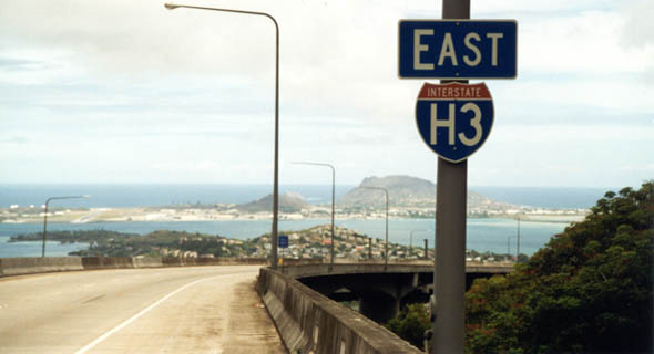 |
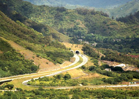
 A scenic
view of Kaneohe Bay, from the H-3 viaduct exiting the Tetsuo Harano tunnels
through the Koolau Range, showing why H-3 is widely considered one of the
nation's most beautiful Interstates. For environmental and historic preservation reasons, H-3 was built mostly as tunnel or viaduct. That contributed to the highway's $1.3 billion price tag (probably the most expensive Interstate per mile, until Boston's "Big Dig" blew that record out of the water), but at least the designers made it a very scenic route. (September 1999) A scenic
view of Kaneohe Bay, from the H-3 viaduct exiting the Tetsuo Harano tunnels
through the Koolau Range, showing why H-3 is widely considered one of the
nation's most beautiful Interstates. For environmental and historic preservation reasons, H-3 was built mostly as tunnel or viaduct. That contributed to the highway's $1.3 billion price tag (probably the most expensive Interstate per mile, until Boston's "Big Dig" blew that record out of the water), but at least the designers made it a very scenic route. (September 1999)
|
 |
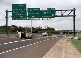 |
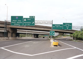
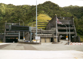
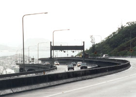
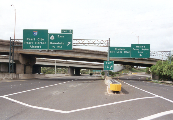
Interstate
H-3's west end is technically at the junction with the Moanalua Freeway
(Interstate H-201, back when it was signed as state route 78), though driving straight ahead through the junction will take you onto long ramps to westbound and eastbound Interstate H-1. The photo on the left is an overview of the junction, from the westbound roadway north of the junction. The photo on the right shows the unmarked formal end of H-3, 0.04 miles past the exit 1B off-ramp to the eastbound Moanalua Freeway. (Both photos November 2001)
|
|
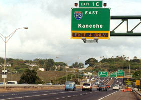
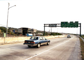
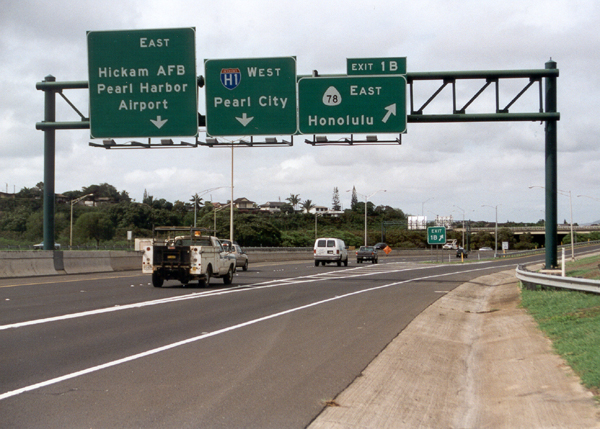
 The exit
to H-3 from the Moanalua Freeway eastbound. H-3 was built with sophisticated
computerized traffic management systems, including the electronic display
on this overhead exit sign. (May 2000) The exit
to H-3 from the Moanalua Freeway eastbound. H-3 was built with sophisticated
computerized traffic management systems, including the electronic display
on this overhead exit sign. (May 2000) |
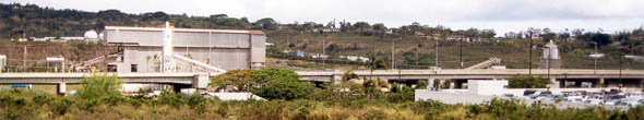 |
 H-3 continues north on its least glamorous section, passing through an
industrial area (and also past a state prison) in the southern end of the
Halawa Valley, just north of the Moanalua Freeway junction. (Both photos
May 2000) H-3 continues north on its least glamorous section, passing through an
industrial area (and also past a state prison) in the southern end of the
Halawa Valley, just north of the Moanalua Freeway junction. (Both photos
May 2000)
|
|
|
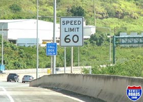
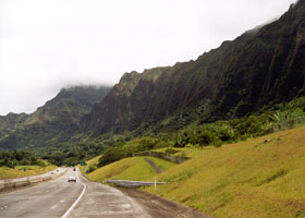
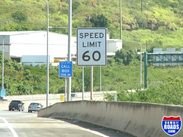
Hawaii was the last of the 50 states to hang on to the speed limit imposed by the old 55 mph National Maximum Speed Limit. In 2002, Hawaii DOT lightened up a little (a byproduct of public outcry over a short-lived photo speed enforcement program), posting a few stretches of freeway at 60 mph (none yet at 65 mph or higher), like this stretch of H-3 entering the Halawa Valley northeast toward the Koolau Range. (October 2004, courtesy of Ryan Ozawa)
|
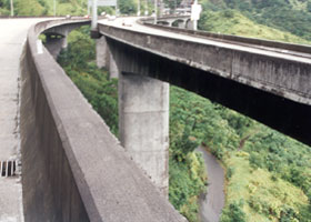
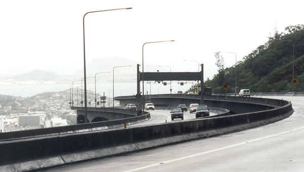
The H-3 viaduct through
the more scenic part of the Halawa Valley, as it approaches from the west
the tunnels through the Koolau Range. At the lower right is an access road
winding through the valley underneath the freeway, which begins at the
back of an HDOT maintenance yard, and is closed to the general public.
(May 2000)
|
|
 |
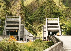 |
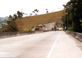
The west and east portals, respectively, of H-3's Tetsuo Harano Tunnels,
about a mile long, through the Koolau Range. (Both photos September 1999)
|
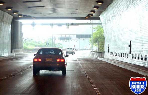 |
Eastbound H-3 approaches the east portal of the Tetsuo Harano tunnels through the Koolau Range, where it will continue on a long viaduct above the Ha'iku Valley. The tunnel has two full lanes in each direction, with full shoulders, and raised reflectors delineating the lanes and shoulders. (October 2004, courtesy of Ryan Ozawa)
|
An overview
of the H-3 east portal and the twin windward viaducts approaching the portal,
from the scenic but strenuous "Stairway
to Heaven" trail above Ha'iku Valley. The trail is currently closed, though it has
been completely revamped and efforts are underway to reopen it. (Photo courtesy
of Michael Gawley.) |
|
 |
 |
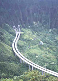
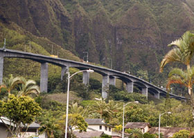
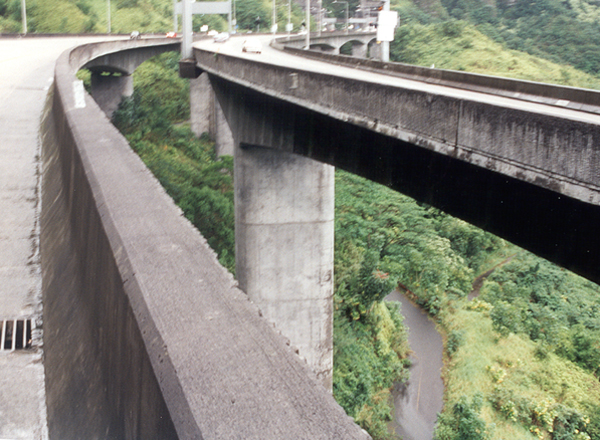
Two views
of the twin viaducts between the Tetsuo Harano and Hospital Rock tunnels,
to the east (above left), and to the west with a glimpse of a trail running
under the viaducts (above right). (Both photos November 2001)
|
 |
 |
The H-3 twin
viaducts approaching the tunnels' east portal, as they pass above the community
of Ha'iku. (September 1999)
|
The viaducts'
eastern end, at the cut-and-cover Hospital Rock tunnels. (September 1999)
|
 |
 |
H-3 east of
the Hospital Rock tunnels, from the Nuuanu Pali overlook off state route
61 (more Nuuanu Pali photos on another page).
(September 1999)
|
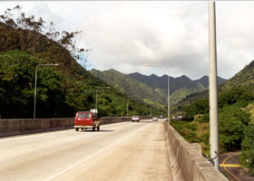
H-3 eastbound,
with the Koolau Range to the right. (September 1999) |
 |
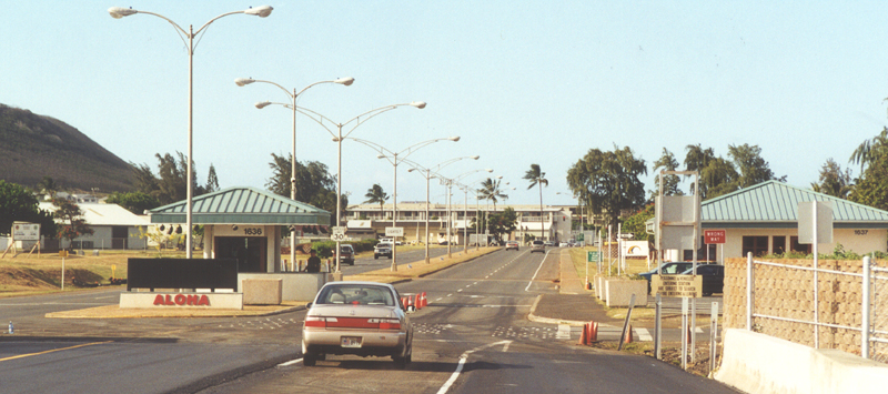
 Two views of H-3's east end, at the main gate to Kaneohe Marine Corps Base
Hawaii. The photo above was taken in September 1999; the one below, in
May 2000. H-3's exact east end is 26 feet past the culvert from which I
took the 2000 photo, within the crossover just short of the guard station
(so unless the crossover is blocked to prevent a U-turn, you can cover
every inch of H-3 without having to clear Kaneohe MCBH security).
Two views of H-3's east end, at the main gate to Kaneohe Marine Corps Base
Hawaii. The photo above was taken in September 1999; the one below, in
May 2000. H-3's exact east end is 26 feet past the culvert from which I
took the 2000 photo, within the crossover just short of the guard station
(so unless the crossover is blocked to prevent a U-turn, you can cover
every inch of H-3 without having to clear Kaneohe MCBH security). |
|
Some other sites:
Hawaii DOT's
Interstate H-3 page has information on the highway and its history,
including a booklet
with several gorgeous aerial photos of the highway before it was completed
in 1997, and a
motorists' guide with lots of detail about the Tetsuo Harano Tunnels and
other freeway features. See also Hawaii
DOT's home page, also featuring an aerial photo of the H-3 viaduct
as it approaches the east portal of the tunnels through the Koolau Range.
An article
in the Honolulu Star-Bulletin just before H-3's completion, one
on the highway's opening day, and a
diagram of the Trans-Koolau tunnels in a third article, provide various
interesting details about Interstate H-3's construction and history, including
some photographs and illustrations.
Articles in engineering publications about Interstate H-3 (all with
photos):
Craig Sanders, H3:
The Island Interstate, Public Roads, Summer 1993 (lots of construction
photos)
Ray Bert, "Paradise
Crossed", Civil Engineering, July 1998
Barbara Braswell, "Pride
in Accomplishment: Completing the Interstate H-3", Public Roads, May/June
1998
Mark Furqueron's
Hawaii road photos page has some more H-3 photos.
In addition, Ryan Ozawa's new HawaiiRoads.com site has lots of additional H-3 photos.
Malamapono's Home Page, and
another
article in the Honolulu Star-Bulletin just before H-3's completion,
describe the objections of some native Hawaiians to the H-3 project (particularly
its routing through the Halawa Valley, the legendary birthplace of the
Hawaiian earth mother Papa, and its impact on many ancient Hawaiian temples
and other sites there and some east of the mountains), and their belief
that Interstate H-3 has been subjected to a "hewa" (curse) as a result.
You can't say you haven't been warned! (However, the funny stuff that supposedly
occurred during construction seems to have died down once the freeway was
opened -- H-3 has a sophisticated accident monitoring system due to its
relatively remote location, and maybe the gods don't like to perform on
camera ;-)
Go to the previous or next parts of the Hawaii Highways road photos collection:
or directly to other parts:
Overview · Other
Freeways · Other Oahu South · Other
Oahu West
Other Oahu East · Kuhio Highway
· Other Kauai · Hana Highway
Piilani Highway · Kahekili Highway · Other Maui · Lanai/Molokai
Kalawao County · Saddle
Road · Observatories Roads · Lava Closures
Red Road · Waipio
Valley · Other Big Island
or to other sections of the Hawaii Highways site:
Comments, etc.? Please e-mail me.
© 1999-2006 Oscar Voss. |


