| Hawaii Highways Road Photos -- Hana Highway (page 2 of 2)
This is page 2 of photos, from my October 1999, May 2000, and November
2001 visits to Maui (plus one historic road photo), of the Hana Highway along the northeast and east Maui coasts (state routes 36 and 360, and part of county route 31). Page 1 provides introductory information about the entire highway, including
a map, plus photos of or from the highway from Paia near its western end, east
to the end of state route 360 in Hana. The photos below complete the journey,
over county route 31 from Hana to Kipahulu, where the Hana Highway meets
the Piilani Highway (remainder of
county route 31) at Kalepa Gulch. This page covers the county route
segment of the Hana Highway in reverse milemarker order, from north
(mile 51.8) to south (mile 38.6), for continuity with page
1.
NOTE: In case you want more detail, clicking some of the photos
below (for now, just some from my 2001 trip) will call up enlarged, higher-quality
(less .jpg compression) versions. Those alternate versions have larger
file sizes, so please be patient while they download.

Page 1: introduction, and Paia-Hana
|
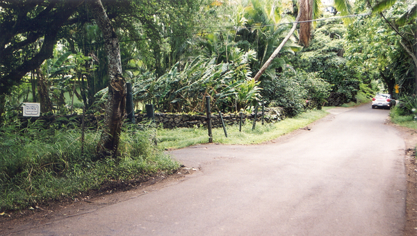
 South of
Hana on the way to Oheo Gulch, the road is part of county route 31 rather
than state highway 360 (which ends at the Hana Bay wharf), but is generally
considered part of the Hana Highway. The road does become narrower and
twistier south of Hana, however. (May 2000) South of
Hana on the way to Oheo Gulch, the road is part of county route 31 rather
than state highway 360 (which ends at the Hana Bay wharf), but is generally
considered part of the Hana Highway. The road does become narrower and
twistier south of Hana, however. (May 2000) |
|
 |
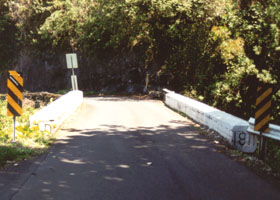 |
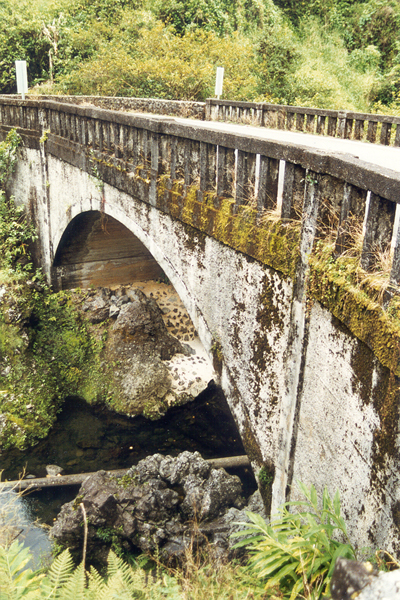
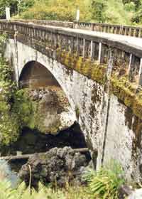
 These two
narrow bridges on the highway between Hana and the Oheo Gulch have
their 1911 construction dates incised on the side (the South Wailua Stream
Bridge at mile 44.7 of county route 31, above left) or the ends (the Paihi
Bridge, near mile 45 of county route 31, above right). (May 2000) These two
narrow bridges on the highway between Hana and the Oheo Gulch have
their 1911 construction dates incised on the side (the South Wailua Stream
Bridge at mile 44.7 of county route 31, above left) or the ends (the Paihi
Bridge, near mile 45 of county route 31, above right). (May 2000)
|
|
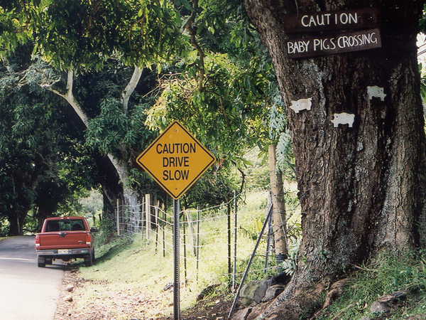
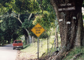
 The Hana Highway's
famously cute, unofficial "Baby Pigs Crossing" sign is on this tree at
mile 45.4 of county route 31, southbound between Hamoa and Kipahulu. (November
2001) The Hana Highway's
famously cute, unofficial "Baby Pigs Crossing" sign is on this tree at
mile 45.4 of county route 31, southbound between Hamoa and Kipahulu. (November
2001) |
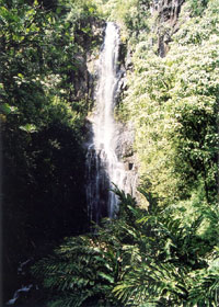
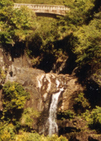
Wailua Falls, right
next to the road at mile 44.7 of county route 31, is a favorite stop
for tourists. Fortunately, it is at one of the few wide spots on this narrow
road, with room for several cars to park. (November 2001) |
|
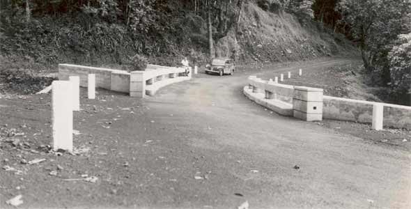 |
This 1948 photo shows the Wailua Bridge below Wailua Falls, back when the Hana Highway south of Hana was still an unpaved road. (Bureau of Public Roads, U.S. Department of Commerce; located in archived BPR records, project file FAS-215(1), box 131, records group 30; courtesy of the National Archives and Records Administration - Pacific Region, San Francisco)
|
 |
 |
Near mile
41.7 of county route 31, the Hana Highway crosses Oheo Gulch at the eastern
end of Haleakala National Park, south of Hana in east Maui, above the uppermost
of what used to be hyped as the "Seven Sacred Pools." (That's a misnomer
-- there are more than seven, and they're no more sacred than any other
pools in Hawaii.) (October 1999 and November 2001 respectively)
|
|
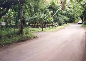
In Kipahulu, at mile
40.8 of county route 31, facing southbound, the turnoff to a small country
church cemetery where Charles Lindbergh is buried. Lindbergh went to live
in Kipahulu after he was diagnosed with incurable cancer. (November 2001) |
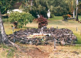
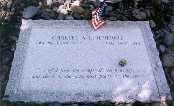
 Charles Lindbergh's grave, and a closer view below showing the inscription
from Psalms 139:9. (October 1999 and November 2001, respectively) Charles Lindbergh's grave, and a closer view below showing the inscription
from Psalms 139:9. (October 1999 and November 2001, respectively) |
 |
|
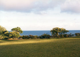
Lindbergh chose a very
serene final resting place, in this clifftop cemetery overlooking the Pacific.
(October 1999) |
|
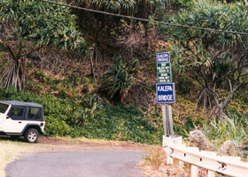 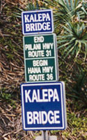 |
There is a lot of confusion about exactly where the Hana Highway ends,
but it is usually considered to end south of Highway 360's end in Hana,
to run at least as far as Oheo Gulch. This sign at the Kalepa Bridge just
south of Kipahulu, at mile 38.55 on county route 31, supplies what I consider
a reasonable demarcation point between the Hana and Piilani Highways, even
though the route number information is seriously outdated (route 36 no
longer reaches into east Maui, and the mileposting for route 31 continues
north about a dozen miles to Hana). It also is consistent with county planning
documents, identifying county route 31 between Hana and Kipahulu as part
of the Hana Highway historic district. Certainly this is the point by which
most tourists have chickened out and turned back -- the Piilani Highway south of here is even more difficult than the Hana Highway,
a very narrow highway with very sharp blind turns, and becoming
unpaved a few miles later. Here also, the population thins out, and the
lush greenery of the Hana area starts giving way to the drier and less
vegetated landscapes of upcountry south Maui. (Both photos October 1999)
|
Maui County commissioned
a study, completed in 2001, of the county-maintained bridges on the county
route 31 segment of the Hana Highway, covered in the photos on this page.
The study focused on needed maintenance or sometimes replacement of the
bridges, consistent with their historic designation as part of the Hana
Highway Historic District. It includes lots of great bridge photos.
The
complete report can be downloaded from the Hana Bridges page of the Maui
County web site (page works best in Internet Explorer; long 15 MB download).
If you just want to review the photos, you can selectively download from
that page Appendix A (four parts, 5 MB total download).
See also the Hana
Highway page of my Road Geek Souvenirs Collection to see some colorful
Hana Highway T-shirts and other souvenirs I brought back from Maui.
|
Kurumi has
jokingly suggested (if my conscience ever evaporates, he emphasizes)
building a six-lane Interstate tollway to replace the Hana Highway, to
reduce travel times from three hours to thirty minutes, and thereby "enhance
economic development in the Hana metro area." After 10 rides down this
tollway, he proposes giving away a free T-shirt. That suggestion inspired
this proposed T-shirt design by C.C. Slater
(featuring a gecko, Maui's "official" reptile).
|

|
Some Hana Highway books:
Angela Kay Kepler, Maui's Hana Highway (1995). Very, very
detailed guide to the highway, with lots of gorgeous photos of sights along
the way (especially the flowers).
Barbara and Robert Decker, Road Guide to Haleakala and the Hana
Highway (1992). The Hana Highway section is short, but has detailed
directions to the best places to stop along the way, as well as lots of
photos.
Richard McMahon, Scenic Driving Hawaii (1997) is a great guide
to scenic Hawaii roads in general, and includes an eight-page guide to
the Hana Highway (including brief coverage of the Piilani Highway).
Richard Sullivan's Driving
and Discovering Hawaii: Maui and Molokai (1998) includes about three
dozen pages full of wonderful Hana Highway photos, as well as handy hints
on where to stop to take your own photos.
J.D. Bisignani, Maui Handbook is one of the Moon Travel Handbooks
which were my main trip planning reference for my trips to Hawaii. It includes
a 30-page discussion of the Hana Highway (including brief coverage of the
Piilani Highway).
Some other sites:
Mark Furqueron's
Hawaii road photos page has some Hana Highway photos.
Ed and
Chris's ("Cactus Hill") Hana trip photo gallery
About.com Hana Highway photo gallery
Discovering
Hawaii photo collection
Ekahi Tours photos of
its Hana tour
or go to the previous or next parts of the Hawaii Highways road photos collection:
or directly to other parts:
Overview · Introduction ·
Interstate H-3 · Interstate H-1 · Other Freeways
Other Oahu South · Other Oahu West · Other Oahu East · Kuhio Highway
Kahekili Highway · Other Maui · Lanai/Molokai · Kalawao County
Saddle Road · Observatories Roads · Lava Closures · Red Road
Waipio Valley · Other Big Island
or to other sections of the Hawaii Highways site:
Comments, etc.? Please e-mail me.
© 1999-2008 Oscar Voss (no copyright claimed on National Archives photo, which is in the public domain). |